Today we at CatSynth and countless others celebrate the 75th Anniversary of the Golden Gate Bridge.
![]()
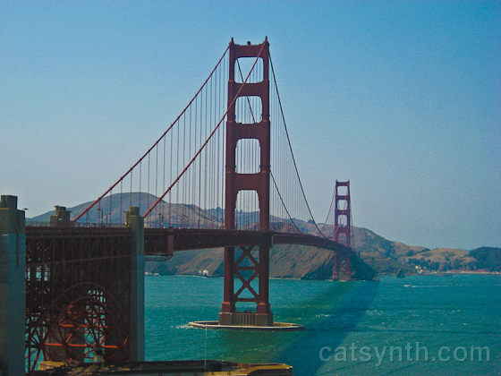
The tallest suspension bridge in the United States, the second longest, and painted in International Orange, it is instantly recognizable. In a sense, the Golden Gate Bridge is San Francisco’s “Empire State Building”. Both are iconic architectural centerpieces that represent their respective cities, and both date back to the 1930s and feature the distinctive Art Deco elements of the era. Both are often present in the background during everyday life of the cities. And (at least for me), they are also places rarely visited except when hosting out-of-town visitors.

 But the Golden Gate Bridge is an important practical part of the city. It is a busy transportation carrying US 101 and California Highway 1 north from San Francisco into Marin County and points beyond on the north coast. It is very unusual for a modern roadway in that the opposing lanes are separated only by short poles that are moved to adjust the number of lanes in each direction. It seems a bit quaint, in fact. On the city side, the highway split into a boulevard carrying CA 1 south and Doyle Drive (US 101) until this past month when the latter was demolished. From these points, travelers are dispersed onto the city streets of San Francisco. There is no easy highway or rail connection between my part of the city (near the Bay Bridge) and the Golden Gate Bridge, owing to the city’s hilly geography and quirky political history. As such, I find myself not near the bridge very often except when I need to be. But when I am nearby it is worth stopping to take notice.

This is what we most often see when we look at the bridge, the orange structure partially shrouded or occasionally completely enveloped by another of our famous landmarks, the San Francisco fog. But the interplay of the fog, the bridge structure, and the other natural and human elements of landscape can make for interesting compositions.

With the anniversary upon us, much attention is being paid to the history of the bridge, its engineering as well as the politics and economics surrounding its construction. For me, the most interesting part of the history is the work of Charles Ellis, a senior structural engineer and mathematician. In many ways (including his early academic credentials), he was more mathematician than engineer, and did much of the theoretical work on the design of the bridge with large amounts of detailed mathematics, along the way publishing highly cited works such as “Williot Equations for Statically Indeterminate Structures” in Transactions, American Society of Civil Engineers, 1935. Indeed, he is now recognized as a principal designer of the bridge, but at the time he was not given any credit after being fired by Joseph Strauss, chief engineer of the bridge project. He was only officially given credit in 2007 (as described in this San Francisco Chronicle article).
This film from the time chronicles the building of the bridge, but also exemplifies the mythology that Strauss created around himself.
Nonetheless, the bridge itself opened to huge fanfare, as seen in this Prelinger Archives film:
Another copy of this video can be found here.
The festivities for this year’s 75th anniversary began about a month ago with the demolition of Doyle Drive, the elevated highway connecting to the bridge.

[Photo by toyzrus8 on flickr. (CC BY-NC 2.0)]
The old highway had elements such as metallic beams in the International Orange color that connected it to the bridge, and it definitely looked to be of the same vintage. It is being replaced by the new Presidio Parkway that will more gracefully connect to the surrounding parkland but also contain the iconic orange color and architectural elements to connect it to the bridge.
Today’s festivities include a planned fireworks display at the bridge. Perhaps most notably there is an ongoing art exhibit at Fort Point called International Orange in which several prominent artists present works inspired by the bridge. I am hoping to see this exhibit soon (perhaps on a quieter day when I can observe the pieces in detail). I did see a preview recently at one of last weekend’s art fairs where Anandamayi Arnold wore one of her dresses for the exhibit, appropriately colored in International Orange. I am also inspired by the concept of this project and the mathematical work of Ellis described above to try my own hand at a creative piece in honor of this occasion.
Please join us in wishing the Golden Gate Bridge a happy 75th Anniversary!


.svg") When bridge first opened, it carried US Highways 40 and 50 as well as the trains from the Key System in the East Bay. The upper deck had longer ramps leading to Harrison and Bryant Streets at 5th, roughly the same as the rather long ramps at those streets today. On the Oakland side, the bridge had viaducts from Cypress Street (Highway 17) as well as San Pablo Avenue and the Eastshore Highway (US 40). The bridge now carries Interstate 80 across the bay. The railway is long gone. Gone also are the connections to the old Transbay Terminal and Embarcadero Freeway, both of which have been demolished. The area under the bridge on the San Francisco side, once a gritty industrial waterfront, is now a picturesque boulevard that is great for walking. Through all of the changes, the bridge itself has not changed very much at all…
When bridge first opened, it carried US Highways 40 and 50 as well as the trains from the Key System in the East Bay. The upper deck had longer ramps leading to Harrison and Bryant Streets at 5th, roughly the same as the rather long ramps at those streets today. On the Oakland side, the bridge had viaducts from Cypress Street (Highway 17) as well as San Pablo Avenue and the Eastshore Highway (US 40). The bridge now carries Interstate 80 across the bay. The railway is long gone. Gone also are the connections to the old Transbay Terminal and Embarcadero Freeway, both of which have been demolished. The area under the bridge on the San Francisco side, once a gritty industrial waterfront, is now a picturesque boulevard that is great for walking. Through all of the changes, the bridge itself has not changed very much at all…


