Today we continue our “primary highways” tour with a virtual visit to Michigan, and in particular to Detroit.
My most significant visit to the state took my to Ann Arbor and the University of Michigan for a music technology conference. The conference was a great experience, of course. The campus what quite interesting as well. As with many traditional college campuses, it has an iconic bell tower, Burton Tower. But it has a second one as well on the modernist North Campus. Our conference required going back and forth between the two where we could easily see the contrast between the traditional collegiate architecture and the modernist, which I quite liked but my colleagues derided.


 If instead of going west from airport to Ann Arbor on I-94 we had instead gone east, we would have arrived in Detroit. I have yet to visit Detroit, and as such the city has taken on a mythical quality. I-94 enters the city as the Edsel Ford Freeway, mostly staying to the north of the city center. We can turn south onto I-75, the Chrysler Freeway to head downtown. One would expect the “motor city” to have an impressive network of freeways. I-75 runs along the edge of downtown as the Fisher Freeway, and together with I-375 and Michigan Highway M-10 form a loop around downtown, anchored by some large interchanges on either end.

As one can see in this map, the loop frames the downtown and Grand Park Circus. The famous People Mover is primarily located within the boundaries of the loop as well. But us now turn our attention to the surface level, beginning with this view from the connection between M-10 and I-75.

[Photo by ifmuth on flickr. (CC BY-NC-ND 2.0)]
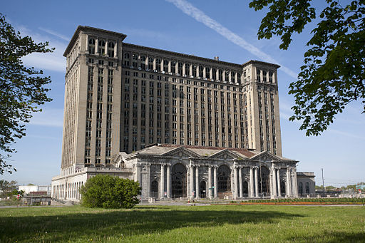
That large building behind the highways is Michigan Central Station (or sometimes Michigan Central Depot, perhaps someone can tell us which is the correct name actually is).

[Albert duce [CC-BY-SA-3.0 or GFDL], via Wikimedia Commons]
The massive and once upon a time grand train station now sits alone and abandoned. It symbolizes much about the city and its history, both rise and decline; and people have very strong opinions about it. It’s “heartbreaking” to some who love Detroit. Some see potential for it to have new uses in the future, perhaps as green revitalization project. Others simply see it as an “eyesore” that needs to be removed. For me, it is quite captivating as a quintessentially American form of “ruin.” We tend not have ruins, preferring to remove that which offends us in favor of bigger, faster, newer, etc. And ruins from the 20th century seem even more vulnerable to our need to remove and remake. But perhaps more than most large cities, Detroit stands out for its ruins that remain. This in part because the city was the center of our iconic automobile industry, and quite prosperous with grand buildings and streets. The decline and decay are quite dramatic, but happened in such a way that many of the places are still there in their decayed state. I first became fascinated with this through the website The Fabulous Ruins of Detroit, which is a loving tribute to the city and its ruins, albeit a melancholy one. And for me, these ruins can be as much a source of creative inspiration as the landscape of Arizona that we explored yesterday. Indeed some of the basic elements of color, shape, texture and sound have things in common, although the human factor is quite different. There is definitely more that Dystopian feel here. I could certainly see music and image inspired by visiting the ruins of the abandoned Packard Automobile Factory.

[By Albert duce (Own work) [CC-BY-SA-3.0 or GFDL], via Wikimedia Commons]
I hope to have the opportunity to visit the city and explore creativity and meet people in the local community there, and make something to share. I hope perhaps the city can find a way to live with its ruins and draw from them without it having to be “blight”, and that vital communities, perhaps greener communities, can grow up within them. Some of the old towers around Grand Circus Park are being redeveloped at this time. And this is all the context of positive news from “Detroit” the automobile industry.

[By Andrew Jameson (Own work) [CC-BY-SA-3.0 or GFDL], via Wikimedia Commons]
In the meantime, there certainly are plenty of cultural opportunities. The Detroit Institute of Arts and the Museum of Contemporary Art Detroit (MOCAD). We have been shadowing the artist Mark Di Suvero throughout this series, and the DIA has two of his works, including an older piece Tom made primarily from wood. Music of Detroit is of course legendary. I have a fondness for quite a lot of classic Motown, much of which was done before they moved – I tend to think it works best in minor keys or when the overall sound is a bit more melancholy than when it is at its most bouncy and upbeat, but that is perhaps just me. Detroit also has a place in the history of popular electronic music. To me, these are not as disparate as others might think, particularly when one considers the harmony. (On this note, I would also enjoy hearing suggestions of music in the comments.)


 But it is time to get back on the road. We can head northwest from Detroit on I-96 to Lansing, the state capital. For those like me who are amused by highway trivia, in Lansing, I-96 and I-69 meet, and even run concurrently for a brief period of time. I think this only place where there is such a mirror-image concurrency (as I-87 and I-78 in New York actually never meet). A spur I-496 turns off into the center of Lansing, with the state capital building to one side.

[Criticalthinker at the English language Wikipedia [GFDL or CC-BY-SA-3.0], via Wikimedia Commons]

If from Detroit we head north on I-75, we pass through Flint (of Michael Moore fame) and then further away from the Great Lakes that define the state’s geography and into the center of the lower peninsula. But I-75 is also the main highway connection to the Upper Peninsula over the Mackinac Bridge.

[By Jeffness at en.wikipedia. Later version(s) were uploaded by Sam at en.wikipedia. (Transferred from en.wikipedia) [CC-BY-SA-2.5], from Wikimedia Commons]

 North of the bridge, we can switch to US 2 which hugs the shore of Lake Michigan on the southern side of the peninsula. But we can also head inward on M-28, from which we can approach the northern shore along Lake Superior, traveling by many picturesque parks such as Tahquamenon Falls and Pictured Rocks.

[By Attila Nagy (anagy) (Own work) [GFDL, CC-BY-SA-3.0 or CC-BY-2.5], via Wikimedia Commons]

[By MJCdetroit [CC-BY-SA-3.0], via Wikimedia Commons]
M-28 continues on to Marquette, the largest city in the Upper Peninsula even though its population is around 21,000. It is home to Northern Michigan University and the Superior Dome, the largest wooden dome in the world.

[By Bobak Ha’Eri (Own work) [GFDL, CC-BY-SA-3.0 or CC-BY-2.5], via Wikimedia Commons]
In researching this article, I came across the blog Michigan Architecture. This site’s author is a gradulate of Northern Michigan University and is still based in Marquette. I recommend checking out her blog and seeing some of her interesting photograph of unexpected places around the state.
We conclude in the northernmost part of Michigan, Isle Royal. It is far north within Lake Superior, and indeed closer to Minnesota and Canada than it is to the rest of Michigan. It has an odd geography, basically a series of parallel ridges sticking up from the lake.

The middle of the island is a lake, Siskiwit Lake. It is trippy to have a large lake in a large island in a larger lake.

But it gets better. When nearby Moose Flats pond is full, Moose Boulder becomes the largest island in the largest lake in the largest island in the largest lake in the world! I will leave readers to ponder this…