At the southern edge of Los Angeles County lies the Ports of Los Angeles and Long Beach, the two largest and busiest in the United States. They are in some ways an entire separate city, with their own network of bridges and freeways beyond the regular network of Los Angeles and its environs.
 We begin our exploration in a quiet and somewhat industrial section of Long Beach along Willow Road. Seemingly in the middle of nowhere, we encounter the northern California Highway 103, the Terminal Island Freeway which is a major truck route to the port. It might be the heavy truck traffic that accounts for its being in rather poor shape.

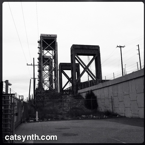
 Heading south on CA 103, we pass through a flat, industrial landscape. It is a bit desolate, but beautiful in its way. There are only two interchanges, one of which is with CA 1. Continuing past the interchanges, the freeway transitions to California Highway 47 and crosses the Cerritos Channel to Terminal Island the ports on the Commodore Schuyler F. Heim Bridge. This is a massive lift bridge that can accommodate large ships accessing the port.

It has an old industrial and dystopian feel to its architecture, particularly on the foggy morning when I visited. Since then, the bridge has been decommissioned and is in the process of being replaced.

I left the freeway at New Dock Street to get a closer look and to take more photos of the bridge and other details of the ports. Photographing around the working port has its challenges with a great many areas fenced off, and a no doubt a heightened suspicion of odd people wandering around with cameras. I did get a few, some of which are shared here. They have also appeared in Wordless Wednesday posts (and will continue to do so).


CA 47 turns onto the Seaside Freeway runs east-west and bisects Terminal Island. Heading east, the freeway (also known as Ocean Boulevard) the graceful Gerald Desmond Bridge, becoming I-710 heading north through Long Beach.

You can read about our separate adventure along I-710 is this article.
Following CA 47 west along the freeway, one winds up and down between elevated and surface sections before ascending to the photogenic Vincent Thomas Bridge.


There is a small park on the west side of the bridge, which affords one a change to get out, walk, and view both the bridge and the channel. There are families and others here, many probably from the adjacent community of San Pedro. We have in an instant left the industrial landscape of the port and entered the residential landscape of greater Los Angeles. It is appropriate the CA 47 ends here and the freeway turns north as I-110, the Harbor Freeway. But that is a story for another time.