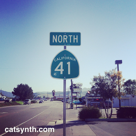
A few years ago, I acquired several highway shields to use in photography, including one for California Highway 41. It was particularly good for photos like that one shown above. But I only knew small bits of the road itself. So when a certain birthday came to pass recently, I decided it was time to travel Highway 41 in its entirety.
Highway 41 begins in Morro Bay at an interchange with Highway 1. Morro Bay is a cute seaside town, and is distinctive for its large volcanic rock along the ocean.


The highway heads northeast through a relatively gentle section of the coast range and crosses US 101 in the town of Atascadero. It then climbs into the hills as a narrow two lane highway. Along the way it passes the many bucolic scenes of farms and ranches. As it climbs the hills, the trees disappear but the landscape remains quite green.

A little further north, Highway 41 joins Highway 46, a major east-west connector, and runs concurrently for a while. The change in traffic and speed was unmistakable.

As one heads east, the land becomes a drier and more sparse. 41 splits from 46 and heads north on its own. After coming over a ridge, the highway descends into a rather arid valley, quite different from the coast and the verdant hills further south.

We cross Highway 33 at a rather unassuming junction. There was an interesting looking roadhouse there, and I wish I had the courage to stop and try it. But I did press on across another, even more arid ridge to a junction with I-5 near Kettleman City. Kettleman City, which is not really a city or even an incorporated town, is probably the single sketchiest location along the entire route. I had been here before and taken a few photos. One of my favorite sites is still “alive and well.”

Continuing north, we move to the interior of the Central Valley at the edge of the former Lake Tulare, once the second largest freshwater lake entirely within the United States. It has since completely dried up, leaving a very flat landscape of farms. Many fields appeared to be fallow, perhaps due to the drought. It is a beautifully bleak landscape.

Just west of the town of Hanford, Highway 41 crosses CA 198, another major east-west highway. 198 is a freeway here, something I was not aware of. 41 itself becomes a four-lane expressway north of the interchange, and increasingly busy as we head north towards Fresno. As we pass the city boundary, it becomes a full freeway. It traverses the area south of downtown as an elevated viaduct, where it crosses Highway 99 and provides access to both downtown and nearby industrial neighborhoods.

I stopped here to do some photographs, one of which already appeared in an earlier Wordless Wednesday. Here are some more.


Heading north out of Fresno, 41 becomes the Yosemite Freeway, as it heads north towards the park.

The freeway narrows and then becomes a surface road as it approaches the foothills of the Sierra. The road climbs steeply into the hills and then descends equally steeply into the town of Oakhurst. The road narrows and climbs again into more mountainous wooded terrain.

We find the signed END of Highway 41 as we approach the southern border of Yosemite National Park.

But this is not the end the real end. The legal definition of Highway 41 continues into the park, although it is not signed as such. It goes through a tunnel the exit of which provides spectacular views of the Yosemite Valley.

Ultimately Highway 41 ends at a junction with (also unsigned) Highway 140 as it enters the valley.
This was an interesting road to complete beyond its numerical value in that it crossed through so many terrains and parts of the state. And a worthwhile and unique trip.
