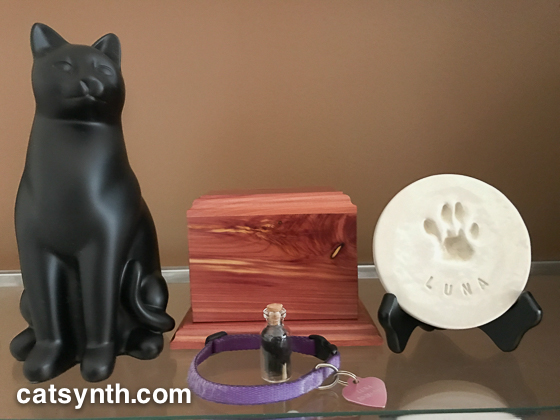
Today I brought Luna home, on what would have been her official 12th birthday. She has a place of honor on one of our most prominent shelves, with her remains as part of a shrine.

Her ashes are in the wooden box in the center. It has a picture frame, which I still have to fill. There were over 500 photos of Luna posted on CatSynth, and many more in my archives. It will take some time. To the right is her paw print, part of the normal custom from cremation of a beloved pet. And the small vial contains a bit of her beautiful fur that I saved from when she was alive.

She has good company, with her shrine between some of our prized feline objects: a large maneki neko from Tokyo and a cat silk painting from Suzhou in China.

To say this is emotional is an understatement. But I hope I continue to do my best by her remains and her memory.
Included with Luna’s remains was a lovely printed copy of the story of the Rainbow Bridge. As the Mourners’ Kaddish is to Jews, the story of the Rainbow Bridge is to animal lovers of all heritages. There are variations, but we reproduce this poetic version below.
By the edge of a woods, at the foot of a hill,
Is a lush, green meadow where time stands still.
Where the friends of a man and woman do run,
When their time on earth is over and done.
For here, between this world and the next,
Is a place where each beloved creature finds a rest.
On this golden land, they wait and they play,
Till the Rainbow Bridge they cross over one day.
No more do they suffer, in pain or in sadness,
For here they are whole, their lives filled with gladness.
Their limbs are restored, their health renewed,
Their bodies have healed, with strength imbued.
They romp through the grass, without even a care,
Until one day they start, and sniff at the air.
All ears prick forward, eyes dart front and back,
Then all of a sudden, one breaks from the pack.
For just at that instant, their eyes have met;
Together again, both person and pet.
So they run to each other, these friends from long past,
The time of their parting is over at last.
The sadness they felt while they were apart.
Has turned into joy once more in each heart.
They embrace with a love that will last forever,
And then, side-by-side, they cross over… together.
We were helped through Luna’s end-of-life process by the wonderful people Golden Gate Home Hospice and Euthanasia. I found myself heading to their office yesterday to pick up Luna’s remains. They are located in the western part of San Francisco that includes the Sunset and Richmond districts. We often refer to them collectively as “The Avenues.” It’s a part of the city I rarely find myself in these days (although Luna’s general-practice vets were out there as well) but it long captivated me, even before I moved to the city.
It was a dreary, rainy day as I made my way towards the ocean on 19th Avenue, Lincoln Avenue, Sunset Boulevard and then Irving Street. Within sight of the water I stopped at bodega for some needed sustenance. The walls displayed pride in their Sunset neighborhood. The rain turned from a light drizzle to a heavy downpour as I left the bodega and headed to the Great Highway. I turned into Golden Gate Park by that bizarre windmill that symbolizes the western edge of the city. In the rain, the park was quiet and a deep green. I headed out of the park north on 25th Avenue towards Geary Boulevard in the Richmond and my final destination. The Russian heritage in the immediate neighborhood was unmistakable, from the large Orthodox church to the storefronts.
In the office, I was treated warmly and kindly, as any bereaved person should be. But right after picking up Luna’s box, a cat came out from the back of the office and created me enthusiastically, even chatting a bit. I was informed that she doesn’t give this treatment to everyone – knowing cats as well as I do, I don’t doubt that at all. In what was a dark and emotional time, it was a moment of delight to be once again in the presence of a cat.

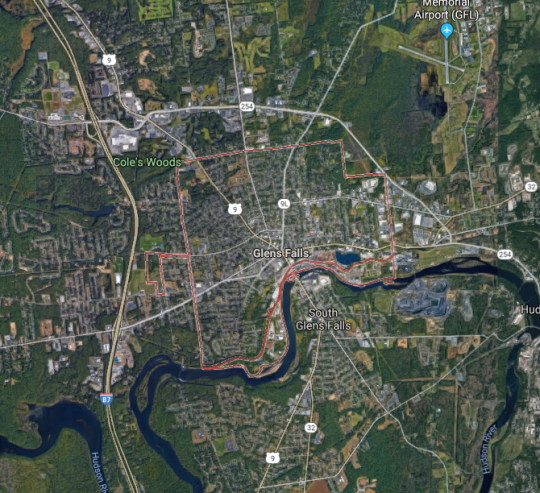


 As we can see from this map, it is just east of Interstate 87, here the Adirondack Northway, so the name for the beer is not at all surprising. US 9 also goes through the town center, as does one of its myriad auxiliary routes, NY 9L, and NY 32 which like US 9 and I-87, follows the Hudson River.
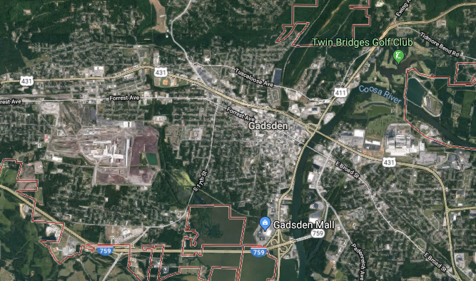


 Gadsden is the largest town in and the county seat of Etowah County and has a population of about 35,000. To put this in perspective, it’s a little over half the size of Santa Cruz, California, where CatSynth began. But unlike Santa Cruz, Gadsden boasts its own Interstate highway, I-759. It begins at an interchange with I-59 west of town and then crosses a long causeway of a wide section of the Coosa River before ending a junction with US 441 and Alabama State Route 759.
 US 441 (Rainbow Drive) continues northward along the Coosa River, passing by the revitalized downtown area bere a junction with US 431 and US 278. It now includes galleries, boutiques, institutions like the


 The geography of San Francisco is complicated, and the east and west sections of the city can sometimes seem quite divided. This is even more so when one is transporting a cat across the city, as I did on Thursday to bring Sam Sam from CatSynth HQ in the downtown area to our longtime vets at

 The Sunset is an interesting and intriguing place, almost a separate city. From 19th Avenue (CA 1), the alphabetically arranged streets and numerically arranged avenues slope gently down towards the Great Highway and the ocean. The Great Highway should be CA 35 all the way up to its northern end, rather than ending in the southern corner of the city along Sloat, but it does. Especially Cats is on Taraval Street, one of the main east-west strips in the neighborhood. It even boasts a streetcar line down to the sea.
 This photo was from 2015 when I brought Luna in for her biopsy. It was a normal overcast gray summer day in the Sunset. Sam Sam’s visit was on a hazy sunny and warm day at the start of the current heatwave. The return to Especially Cats was a warm experience as well, albeit a bit emotional as it was our first reunion since Luna passed away. Fortunately, Sam Sam received a clean bill of health and charmed the staff with her cuteness. And she was remarkably well behaved on the trip over, just complaining a little bit. We decided to take the more geometrically direct but hilly and windy route back, taking Taraval to its eastern end a swanky neighborhood around Laguna Honda, and then over Portola and Market back to our corner of the city. The spot where Market and Portola meet is among my favorite in the city, with commanding views of downtown and beyond. And in between, there are dips and valley with unexplored roads and walks that I need to come back to when I don’t have an impatient cat in a carrier.


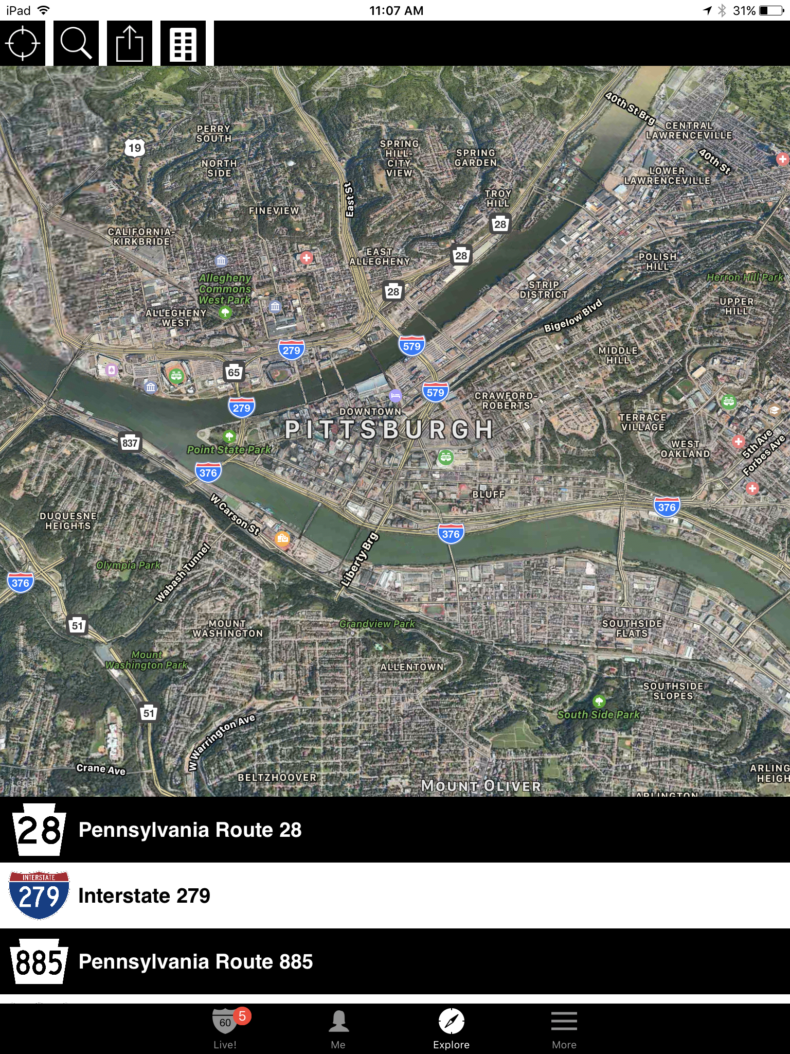


 The downtown is wedged between the two upper rivers and enveloped by a network of highways including I-279, I-376, I-579 and PA 28. In this early-morning photo, we are looking across the Monongahela River, with I-376 along the shore and the skyscrapers of downtown behind it. As a city of rivers, it also becomes a city of bridges.


 We would be remiss if we did not also give a shout-out to our friends at Pittsburgh Modular Synthesizers. We have several of their modules, which feature a classic mid-century design aesthetic. (They also include space-themed cards and tchotchkes in each box.) You can read our
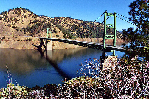


 Highway 162 crosses the bridge, and connects the town of Oroville to Highway 70 and the Sacramento Valley. Highway 162 continues westward towards the wide flat Thermalito Afterbay, a wide shallow reservoir that is part of the Oroville system, and serves both agricultural water delivery and regulation of the main lake and the power plant.
 Highway 70 heads southwards towards Sacramento, passing the towns of Marysville and Yuba City , where it continues as a freeway towards Sacramento. Yuba City is interesting as the home to perhaps the largest Sikh community outside the state of Punjab in India. Many of the Sikh settlers in the area became farmers, in particular peach farmers. And the town hosts a large annual festival that brings in thousands from outside the area.

 We begin our exploration in a quiet and somewhat industrial section of Long Beach along Willow Road. Seemingly in the middle of nowhere, we encounter the northern California Highway 103, the Terminal Island Freeway which is a major truck route to the port. It might be the heavy truck traffic that accounts for its being in rather poor shape.
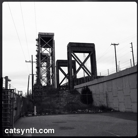
 Heading south on CA 103, we pass through a flat, industrial landscape. It is a bit desolate, but beautiful in its way. There are only two interchanges, one of which is with CA 1. Continuing past the interchanges, the freeway transitions to California Highway 47 and crosses the Cerritos Channel to Terminal Island the ports on the Commodore Schuyler F. Heim Bridge. This is a massive lift bridge that can accommodate large ships accessing the port.


.jpg)