We at CatSynth love traveling and exploring our adopted home state. This includes day trips from the Bay Area as well as longer adventures. But one thing remains a bit of a challenge. For much of the state, the main highways are primarily north-south, with very few east-west routes. One chooses one of the long-haul north-south highways, California 1, US 101, I-5, California 99, or US 395 and is pretty much locked in with only a few options for efficiently traveling east to west. There is I-80 in the middle north, California 152 or California 46 from the coast through the Central Valley and California 58/I-40/I-15 further south.
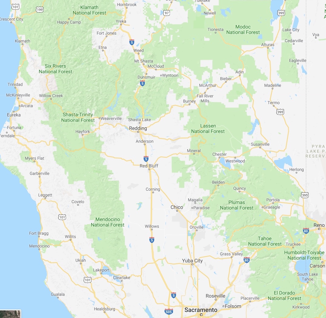
North of Sacramento, east-west travel becomes even more difficult, with routes like California 20 and California 299 being relatively rural and windy for much of their length. The end result is that most of our trips – especially single-day trips heading north – are forward and back along one of the main north-south routes unless we have extra time or necessity to use the smaller east-west roads.
This north-south bias can be seen in an almost self-similar way when zooming in on the extended Bay Area. South of San Francisco, there is California 1, I-280, US 101, I-880, I-680 and then not much at all until one gets to I-5 in the Central Valley.
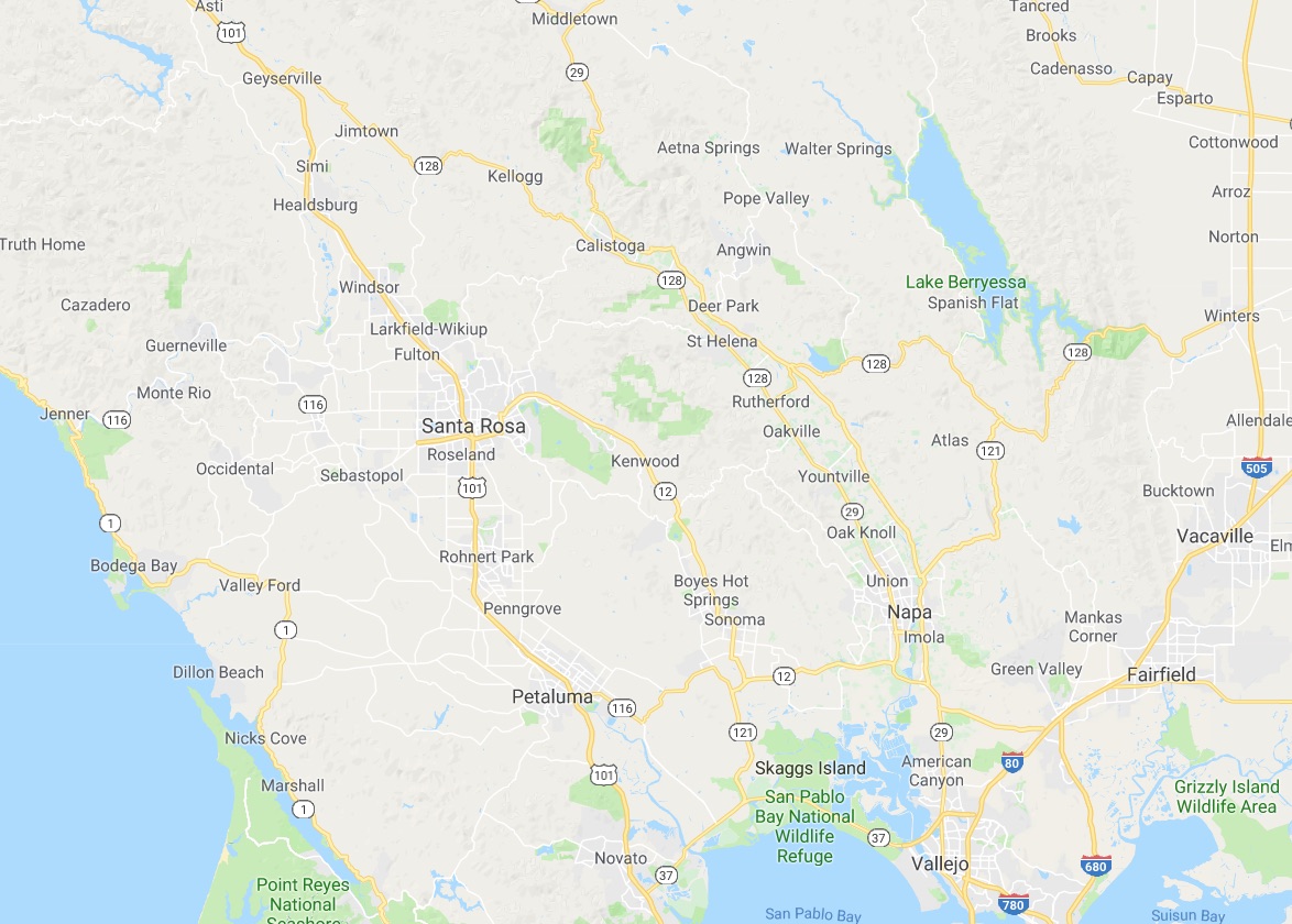
In the North Bay and wine country, a similar pattern appears with CA 1, US 101 and CA 29, with another large gap until I-505 and I-5. We have made use of east-west roads like CA 128 to get between them as in our recent wine-country trip that featured Elsie the Library Cat. But this is a long detour.
This north-south axis may be frustrating at times (especially the further north one gets), but there is nothing particularly sinister about it. It’s all a matter of Calfornia’s geology. The interface of the Pacific and North American plates that give us our reputation for earthquakes also lead to long bands of north-south mountain ranges and valleys. The Sierra Nevada may be the most dramatic, but it is only one of several that form vertical stripes, with the Central, Sacramento, Salinas, and Napa valleys in between. The San Francisco Bay can be seen as another such valley in a way, with shallows bounded by high hills running north-south.
The exception to the “north-south rule” can be found south of the San Gabrial mountains and into the desert. From Los Angeles and San Diego, one can easily travel east-west to the desert towns and to the Arizona border on I-10 and I-8, with a network of other east-west freeways in between. It is definitely a different experience traveling down there once one gets over the Grapevine or the Tehachapi Pass and into the southern realms. As for the rest of the state, there is no escaping the geographic reality, so it is best to embrace it, and even enjoy it.
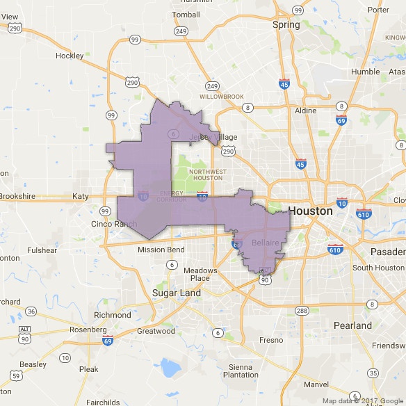
Primary election season is in full swing. In a couple weeks, we will be having one here in California (as well as an election for mayor here in SF). But tomorrow, there is a runoff in Texas’ 7th Congressional District (TX07) in which we at CatSynth are taking a keen interest. As illustrated in the map, TX07 cuts an odd shape through the western neighborhoods of Houston and the adjacent towns in Harris County. It is a diverse area and intersects with all three of Houston’s loop highways, which is no small feat. It includes several wealthy enclaves, but also middle-class neighborhoods, and areas that have been hit by serious flooding during Hurricane Harvey and preceding events.
The southeast “bulge” part of the district includes sections of Houston that lie within the I-610 loop, or “Inner Loop”. I-610 separates the downtown sections of Houston from outer neighborhoods and surrounding communities, including towns like Southside Place. It is bisected west-to-east by the new I-69 (US 59). The area where these two highways intersect would not look out of place in Los Angeles.
Heading north and west, we come to the middle section of the district, which is largely a horizontal rectangle bounded by the mighty I-10 to the north, and which extends almost to Katy in the west. Beltway 8, also known as the Sam Houston Parkway/Tollway, bisects this segment of the district. Just to the west of the beltway are the Briarforest neighborhood and the ominously named Energy Corridor. Not surprisingly, several major energy corporations have operations in this area, as do several other businesses. The Buffalo Bayou – we at CatSynth are still not entirely sure what separates a bayou from a river – cuts through the district. It was subject to major flooding during Hurricane Harvey. In addition to the bayou itself cresting at record levels above flood stage. releases from the Barker Reservoir caused severe flooding in adjacent low-lying neighborhoods. We have sources that have informed us that the floodwaters in the Energy Corridor area were most unpleasant.
The final section of the district cuts an inverted “L” between State Highway 6 and State Highway 99, the outermost loop around Houston, bounded on top by US 290. In all, the district has an odd shape indeed, but not so odd when one considers the tradition of gerrymandering, an art which has been taken to new heights by Texas’ Republican-controlled state government. Its shape has long preserved it as a safe Republican district – it has elected Republicans to Congress consistently since George H.W. Bush in 1966. But the city and surrounding area have been changing, and it is seen as vulnerable to flip to 2018.
Several Democratic candidates have vied to take on incumbent Republican John Culbertson, including Laura Moser, a progressive candidate who also just happens to be the sister-in-law of CatSynth author and founder Amanda Chaudhary. As such, we are watching her candidacy with great interest and excitement. Leading up to the main primary in March, things got a bit nasty, with the DCCC (Demoncratic Congressional Campaign Committee) throwing its weight behind another candidate, more mainstream and connected to the Democratic establishment. This was an unusual move for a suburban primary election, and some of the opposition was rather mean-spirited. But that is a long-standing part of elections, and it only served to galvanize support for Moser, who placed second in the crowded field and made to the runoff which happens tomorrow, May 22. Not having learned their lesson the first time, the DCCC has continued to attack her, including some rather nasty opposition-research-style drops (in some ways, they reminded me of some recent attacks on Jane Kim on our local mayor’s race in SF). But in this case, it was against family, and therefore personal in addition to being against my political views. So we at CatSynth are pulling strongly for Laura Moser in Texas’ 7th Congressional District tomorrow, and hope she wins both the runoff and the general election in November. You can find out more about her history and positions on her website, and if you have any friends in TX07, please encourage them to get out and vote!
Our “primary highways” series continues with a visit to Louisiana. It combines my own visit to New Orleans with a “virtual visit” through other parts of the state.
We start in New Orleans, which I visited in November of 2006, during the recovery from Hurricane Katrina. Coming in from the airport on I-10 we approached the downtown. The highway comes close to the Superdome and the downtown buildings. A large interchange connects to Business US 90, which heads over the Mississippi River via the Crescent City Connection. It was good introduction.
I stayed in the Garden District along St. Charles Avenue. The streetcars which had traditionally run along the St. Charles were still out of service, so I made my way between my home base and Tulane University by walking and enjoying the warm weather. To get downtown, I either walked or used whatever form of transportation I could access. I of course visited the French Quarter, and sampled the food and drink.
But it was also fun to wander the smaller streets, and find odd stores and corners. An occult store, where I found black-cat fur for good luck. An old book store with a resident cat as a host. And an artist selling these cat-themed jazz pictures (does one sense a theme here?).
Being interested in art, I headed up Canal Street on a still function streetcar line to the city park and the New Orleans Museum of Art. The park had suffered extensive damage from which it was still recovering, but the museum had weathered the storm quite well and reopened after a few months.
I spent most of my time in the city sculpture garden adjacent to the museum, which included several modernist works.
On the trip back along Canal Street, I paid closer attention to the buildings along the road. Particularly south of the park but north of the I-10 overpass, there was quite a bit of damage visible, with boarded up houses and entire bulldozed lots. Indeed, throughout the trip is impossible not to see the scars of Katrina.
Just east of the French Quarter was the Fauborg Marigny district. It was a bit funkier, and in retrospect and had that feel I enjoy in many neighborhoods of New York and San Francisco (think Lower East Side, the Mission, etc.). It was here that I sought out opportunities to hear local music. At The Spotted Cat I heard quite a few musicians both in traditional jazz idioms and other styles – this seemed to be music for a local crowd rather than for tourists, which is what I was looking for. And it had a cozy, dark, feel, with quirky lighting and artwork.
I did set aside some time to see what had become of the Lower Ninth Ward. In a rented car, I headed east on Claiborne Avenue (LA Highway 39) and crossed over the canal into the district.
I had of course followed the news and seen many images of the Lower Ninth Ward, but it’s another thing entirely to see it in person. And it’s not just one example, it kept going in all directions. And there were very few people around. It was eerily quiet, just me, the ruined buildings and the occasional car passing by. But the Ninth Ward’s history goes back far earlier than Hurricane Katrina, as it was the site were a certain Homer Plessey was removed from a train for sitting in a white car, leading to the infamous Supreme Court case Plessey v. Ferguson.
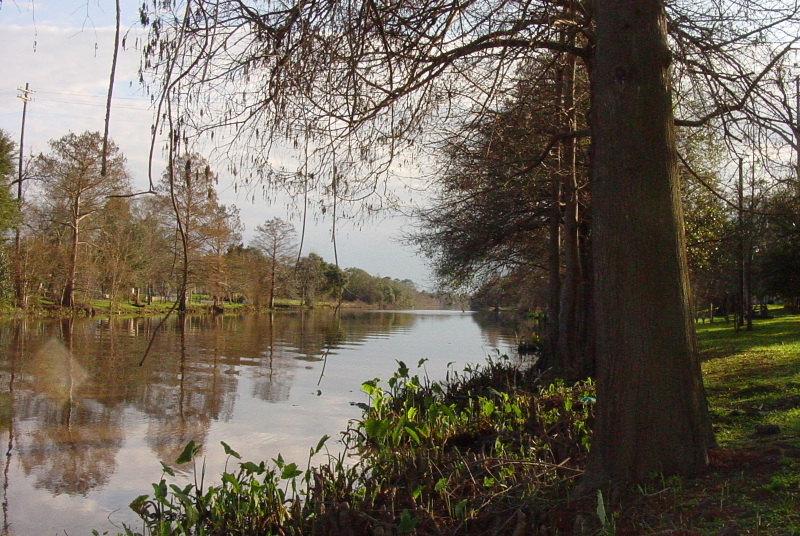
After the Lower Ninth Ward, I headed back across the canal and north to the edge of Lake Ponchartrain. The lake is huge, one can’t really see across it, especially on an overcast day. The waves and wind made me think of the windy Pacific coast of California.
Here, too, there were signs of what happened to the city, all the more ominous with the gathering storm clouds.
I did not actually leave New Orleans on that particular trip. If I had, I could have headed north over Lake Pontchartrain, which is no small feat. The Lake Pontchartrain Causeway is 23.83 miles long, and is ctonsidered the longest bridge over water in the world. (Though there is some dispute of the record the the Jiaozhou Bay Bridge in China.)
One can also cross the lake via I-10 on the Twin Span Bridge. At a mere 5.4 miles, the Twin Spans are dwarfed by the causeway, but it is still a respectable length. The original bridges were heavily damaged in Hurricane Katrina and have been replaced with newer spans. The lake itself tapers off to the east towards The Regolets, which connect the lake to the Gulf of Mexico. The Regolets pass helps regulate the flow of salt water and fresh water into and out of the lake. As Daily Kos member Crashing Vor points out, it “is one of the rare estuarial passes where, at the right time of day, you can fish for salt water species out of one side of the boat and fresh water from the other.”
[Photo courtesy of Crashing Vor on Daily Kos]
It is hard to escape from the regions food while exploring its geography. And in truth, why would one want to.
The eastern edge of New Orleans and Lake Ponchartrain is also home to NASA’ Michoud Assembly Facility, where many of the rocket and spacecraft engines have been built, including the first stage of the Apollo Saturn V rocket, and the external fuel tank of the Space Shuttle.
[Photo courtesy of Crashing Vor on Daily Kos]
Continuing on I-10 and US 90 east, we could head to Mississippi where we began our article on that state. But instead, we return to New Orleans and the banks of the Mississippi River.
[Photo courtesy of Crashing Vor on Daily Kos]
The river, too, is quite wide an impressive as it passes by the Crescent City – the nickname in fact comes from the bend in river as it passes by the city. We cross the river on the Crescent City Connection to the “west bank”, which is actually south here. We continue on US 90 Business and turn south onto LA 23 towards the town of Belle Chase. LA 23 crosses the Gulf Intercoastal Waterway via an old bridge and tunnel pair, and then hugs the west bank of the Mississippi to the mouth of the river.
The geography of southeast Louisiana is strongly shaped by the interaction of the river and the Gulf of Mexco. This is certainly true of New Orleans and Lake Pontchartrain, but it is most dramatic where the river literally pushes into the gulf. The small fractal-like slivers of land are really just a boundary between the two overlapping bodies of water.
LA 23 ends at the town of Venice, which is the last town accessible by standard automobile. The town really is just wedged on one of these fibrous tendrils of land up against the river. Of course, the remainder of the delta is accessible by boat, including the Delta National Wildlife Refuge and the Pass A Loutre State Wildlife Management Area. The natural environment of the delta, as well as towns such as Venice, have been hit twice in the last decade, first with Hurricane Katrina and then with the Deep Water Horizon oil spill in 2010.
New Orleans continues to function as the hub for this particular virtual exploration. We next head west on I-10 and turn south onto I-310, which crosses the Mississippi on the cable-styled Hale Boggs Bridge.
[Photo courtesy of Crashing Vor on Daily Kos]
We then head north (back on the east bank of the Mississipp) via US 61 to the town of Laplace. I was disappointed to find out this was not named for the Laplace transform in mathematics and signal processing, but on the plus side it is known as the “andouille capital of the world”. And we would be remiss if we did not stop here to sample the famous and tasty sausage.
We continue on I-10 past a junction I-12, which covers the northern side of Lake Pontchartrain, and arrive in the capital Baton Rouge.
[Photo courtesy of Crashing Vor on Daily Kos]
The Louisiana capitol building is quite distinctive. Rather than the typical Greek-inspired dome and columns, it is an Art Deco skyscraper. It in fact looks quite a bit like City Hall in Los Angeles. This capitol building was the “pride and joy” of Governor Huey Long. It is also where he ultimately met his demise in this hallway.
[Photo courtesy of Crashing Vor on Daily Kos]
We then cross the Mississippi again and turn south on Louisiana State Highway 1. At first, it follows the west bank of the river, but then heads southward, beginning a long parallel with LA 308 on opposite banks of Bayou Lafourche. We pass the town of Belle Rose, which I had written about in a post last year in an art-damage moment because it contained Highway 998 and fit well with a poem I had written called “998”. Continuing on LA 1 along the bayou, we come to the town of Thibodaux.
[Photo courtesy of Crashing Vor on Daily Kos]
As in New Orleans, the cemeteries are above ground here as well.
South of Thibodaux, we turn west on US 90. The is a major highway and being upgraded to interstate standards, passing by the Bayou Teche National Wildlife Refuge as well as several towns. We turn south onto LA 329 to Avery Island. This actually is not an island at all, but it is a salt mound that rises in an oddly circular fashion from the flat landscape. It is most known for being the home of Tabasco hot sauce. We at CatSynth are of course fans of all things hot and spicy, and so visiting this factory and a tasting session would be in order.
[Photos courtesy of Crashing Vor on Daily Kos]
We continue on US 90, which passes the towns of New Iberia and St Martinsville, on the Bayou Teche.
[Photo courtesy of Crashing Vor on Daily Kos]
We then come to the city of Lafayette, where we cross I-10 and continue northward on I-49. The area along the highway was part of an ancient flow of the Mississippi that apparently was wider and further west than it is today. Heading northward, the wet environment of southern Louisiana gives way to a drier landscape. Via LA 1 we come to city of Natchitoches, which has the feel of an older historic town.
We continue north on I-49 to its end at I-20 near Shreveport, the third-largest city in the state. The bypass highway I-220 spans nearby Cross Lake on a graceful modern bridge. The view from below with the arches is an interesting optical effect.
These dogs in a kayak are also quite admiring of the I-220 bridge.
And we end back along the Mississippi River with this video tribute.
In this installment of our “primary highways” series, we look at the states of Mississippi and Alabama. In some ways, this is a particularly challenging edition, as I have never personally visited either of the states – in fact they are among only five remaining states I have yet to visit (Kansas, which held its causes on Saturday, is another of the five). So we will do the best we can.
I did come close to visiting Mississippi in 2006. For one day while I was in New Orleans, I had rented a car to reach places outside the public transportation grid that was still limited after Hurricane Katrina, including the Lower Ninth Ward. I was tempted to get back on I-10 and head east to Mississippi, just to be able to say I was there. But in the end I decided against it. Had I continued, I would have crossed into Mississippi in a sparsely populated area along the Pearl River. To the north of I-10 is the John C Stennis Space Center, where NASA has tested engines for many of our legendary space vehicles including the Apollo Saturn V and the Space Shuttle.
Given that it is an engine test facility, it’s not surprising there isn’t much of a permanent population in the area. Several communities were removed when it was built, and supposedly a few remnants of the communities, particularly Gaineville, still exist. Indeed, off of Highway 607, the “Shuttle Parkway”, is Lower Gainesville Road, which heads past various space-center complexes towards the Pearl River and ends at what could be the remains of the town.
Heading southward on 607 from I-10, we eventually reach US 90, which continues along the Mississippi coast through the towns of Waveland and Bay St Louis, which were devastated by Hurricane Katrina. Perhaps the most dramatic example was the bridge carrying US 90 over St. Louis Bay, which was completely destroyed.
It has since been replaced by a new bridge, a graceful flowing structure that has won the American Transportation Award and became a symbol for the region.
US 90 continues along the coast as Beach Boulevard towards the cities of Gulfport and Biloxi. Biloxi is a big resort and casino town on the coast, but it, too, was devastated by Hurricane Katrina. Although it sounds like there is still much rebuilding to be done, many of the city’s casinos have since reopened and landmarks restored including the iconic Biloxi Lighthouse and the Ohr-O’Keefe Museum Of Art that was designed by Frank Gehry. The Ohr-O’Keefe was under construction when Katrina hit and was severely damaged. It ultimately opened in 2010.
South of nearby Gulfport is Cat Island. I thought maybe it had something in common with the famous Cat Island off the coast of Japan, but no such luck. As far as I can tell, there are no cats there, and the name itself was a mistake.
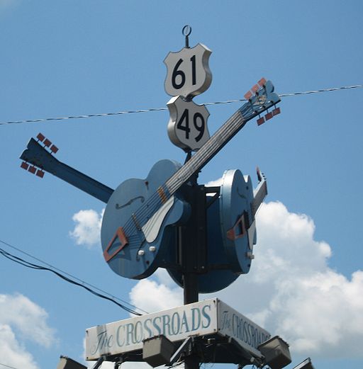
From the southeast corner of the state, we jump to the northwest corner. Specifically, we are going to a junction outside of Clarksdale where US 61 and US 49 meet. This crossroads is considered by many “the crossroads”, where according to legend blues musician Robert Johnson sold his soul to the Devil in exchange for his musical gifts.
Legend or not, Clarksdale has a particular association with the blues, and is home to the Delta Blues Museum.
US 49 has long been a major highway traversing the state diagonally. From Clarksdale, it winds its way through the Mississippi Delta, even splitting into separate east and west parts, before leaving the delta and approaching the capital and largest city, Jackson. On the northwest approach to the capital, US 49 carries the name Medgar Evers Boulevard in honor of the civil rights leader who was assassinated in Jackson in 1963. The highway then bypasses the downtown with I-220 and I-20 before continuing to Hattiesburg, home of Southern Mississippi University.
In Hattiesburg we meet I-59. The drive along I-59 and US 11 to the town of Laurel was recommended to me (actually, the drive south from Laurel to Mississippi State University). In Laurel, I-59 had an unusual S-curve that rivaled Dead Man’s curve in Cleveland due to railroad overpasses, but it has supposedly been reconstructed. I-59 continues north to Meridian, where it joins with I-20.
Briefly leaving the freeway in Meridian, one can take Highway 19 north to the town of Philadelphia, made infamous for the death of three civil rights workers James Chaney, Andrew Goodman and Michael Schwerner. The murders took place off of Highway 19, and it was presumably the route they took to Neshoba County.
I-59 and I-20 continue as a single route into Alabama, all the way to Birmingham. It is largest city in either of the states in this article, and is crisscrossed by several major highways. A large interchange between I-59/I-20 and I-65 just west of downtown is known as Malfunction Junction because of the frequent (and unfortunately, sometimes deadly) accidents that happen there.
[Click to enlarge.]
Interestingly, it does not look that complex from a map view, especially when compared to a nearby junction of I-59/I-20 and US 31/US 280. While it does look more complex, it does afford a good view of the city skyline when approaching from the south.
Birmingham has a strong industrial past, especially in iron and steel. Indeed, the Sloss Furnace in the city is one of the few industrial sites preserved as a National Historic Landmark.
Visitors can wander and enjoy the site, which features defunct but preserved industrial buildings and machinery. This would be a fantastic place to photograph! I could also see it as a musically inspiring location, for pieces based on metallic resonances. The center does hold concerts, and has a highly regarded program in metal arts. (I wonder if they have arts residencies?)
As has happened with many other industrial cities that experienced long declines, downtown Birmingham appears to rebounding as a residential and cultural center, with lofts and galleries. There is also the restored Alabama Theatre which functions as a performing arts center while retaining many of its movie-palace features, most notably its original Wurlitzer Organ. (It should be noted this is the second Wurlitzer to be featured in this year’s “primary highways” series.)
South of Birmingham is the town of Selma, which has a storied place in the Civil Rights Movement. A voting rights movement in the town ultimately grew into the Selma to Montgomery Marches in 1965. The marches took place on US Highway 80 heading east from Selma and crossing the Edmund Pettus Bridge.
The first march was met by state troopers and the marchers were brutally assaulted. Images “Bloody Sunday” were broadcast nationwide, shocking many and galvanizing support among some for the civil rights movement. Two more marches along the same route were organized. The third march passed the bridge and continued all the way east on Highway 80 to Montgomery. The march then veered north onto the Mobile Highway, parallel to present day I-65, and then along city streets to the state capitol. The entire route is now marked as the Selma to Montgomery National Historic Route.
From the state capital, one can travel south on I-65 to Mobile and back to the Gulf Coast, where we began. We switch on to I-165 which enters the downtown and becomes Water Street. Heading further south, we come back to I-10, which crosses Mobile Bay on a long causeway. From the causeway, we can look back at the city at sunset.
This week the primary season brings us to two very different states, each of which are a source of creative inspiration but in very different ways. The first of these states we will visit is Arizona.
We begin where we left of in Colorado. From Four Corners, we head west on US 160 through the Navajo Nation. The dry landscape is punctuated by red rock formations such as Baby Rocks, which can be seen along the highway.
The shapes and textures of the rock formations and the sparseness of the landscape are what attract me to the southwest. The unique combinations of climate, water and rock composition lead to this landscape, and individual varieties of rock (many of which are different types of sandstone) lead to the distinctive shapes in different locations. Sometimes the most interesting can simply be found on the side of the road. But that does not detract from the many iconic parks in this state. Indeed, if we continue on US 160 west to its terminus at US 89, and then further west along State Highway 64, we come to the most iconic of all, the Grand Canyon.
It’s quite hard to summarize the Grand Canyon in such a brief article, but to say that it is most defined by its vast size. One is not simply looking at a large rock formation, but an entire carved landscape that extends in all directions. The space left by the canyon is big enough to support the same atmospheric effects as the sky itself, such as the refraction that leads to a blue tint in the space. Sadly, this also makes it a magnet for air pollution. The scale also means that from a distance one sees the rough surface and curved lines of the overall topography, but not as many distinctive formations like the Baby Rocks described above. To see such details of the Grand Canyon, one must travel to the far sections of the rim or descend into the depths.
For many, places such as this are as much about recreation (rafting, hiking, climbing), but for me the interest in going back sometime soon is primarily about the visual landscape, touching feeling and breathing the desert air, and hearing both the sounds and the silences.
We head south from the Grand Canyon on US 180 to I-40 near Flagstaff. We take I-40 east to another of Arizona’s iconic locations, the Petrified Forest National Park. The eponymous petrified trees were created by combination of trees and minerals that were deposited over long periods of time and the gradual replacement of the organic matter with minerals. The relatively soft and easily eroded sandstone have left a surprisingly large number of these artifacts in one location. The extreme erosion patterns of the area also gave rise to the colorful formations of the Painted Desert.
Leaving the park, we turn back west on I-40 to Flagstaff, and then head southward on I-17 towards the Phoenix metropolitan area and a very different Arizona. But along the way, we pass by Arcosanti, an experimental town and “urban laboratory” that began construction is 1970. It was started by architect Paolo Soleri to experiment with ways of developing urban environments that minimized the impact on the natural environment. The architecture of Arcosanti is quite unique.
And it’s on to Phoenix. It’s hard to conceptualize that in the middle of the desert is one of the largest and fastest-growing metropolitan areas in the United States. Yet there it is. The recent rapid growth of Phoenix and the entire “Valley of the Sun” and the relatively flat terrain have led to some rather impressive highway interchanges.
The rather complex tangle above is the interchange of I-10 (the Papago Freeway coming from downtown Phoenix), Arizona Loop 202 and Arizona State Highway 51, which is supposedly the busiest interchange in the state. A more elegant one (which I have in fact seen in a museum piece) can be found further east where AZ 202 meets US 60.
The lines and curves complement the desert terrain (disregarding the subdivisions for the moment). Indeed, the structures themselves have a reddish color reminiscent of the desert landscape.
Traveling up Arizona Loop 101 to Scottsdale in the northeast corner of the metropolitan are, one finds Taliesin West, the winter home and school of Frank Lloyd Wright. Wright designed this home to reflect “Arizona’s long, low, sweeping lines, uptilting planes”, aspects of the natural landscape which we have explored in this article.
In ways, his goals predate and inform the work that continues at Arcosonti, although the latter has more of an urban focus.
Heading south and east on I-10, we come to Tucson and a very different but still quintessentially “Arizonan” landscape. Here the most distinctive features are not the rocks but the vegetation, especially the saguaro cactus. Like the Grand Canyon, the saguaro is a symbol of the state, and of the best preserved tracts of these and other cacti can be found in Saguaro National Park west of Tucson.
Heading back west on I-10, we switch to I-8 through the southwest corner of this southwestern state. We turn south on State Highway 85 through relatively empty but rocky landscape. Highway 85 intersects with 86 at the small town of Why, named for the “Y” shape of the original intersection of the two highways. Because Arizona law required location names to have at least three letters, the name “Why” was used instead of “Y”. Continuing south on 85, we eventually reach Organ Pipe Cactus National Monument.
Although this park is named for the organ pipe cactus (shown above), it contains many of the other varieties found in southern Arizona, such as the saguaro. However, the converse is not true. The organ pipe cactus only grows wild here. I visited in the winter of 2004-2005 and found this park to be quite sparse and peaceful. The landscape does not really have many of the monumental rock formations further north, but it does have interesting hillsides covered with rough crumbling stone and frequently punctuated by the cacti.
And I think the final desert sunset is an appropriate way to conclude this article. I of course know there is much more to consider in Arizona, and welcome thoughts and ideas from others as comments.
I conclude my series from New Orleans with a visit to the areas beyond the central city and tourist district, areas hardest hit by Katrina. Consider the following overall map of New Orleans:
The Garden District and Tulane University (where the ICMC conference was held) are in the lowel left section. The rectangular area encompasses much of downtown as well as the French Quarter and the Fauborg-Marigny district (home of the Spotted Cat featured in my article on night life). These are highlighted in red and yellow, respectively, below:
To the east of Marigny are the Bywater neighbhood and the Lower Ninth Ward. The latter is probably known to many readers as the site of some of the worst flooding and destruction from the storm.
Heading out of Marigny north on Elysian Fields Ave., the trendy crowded neighborhood gives way to a more spread-out “Los Angeles” style area of separated buildings, convenience stores. Much of this area appears to be functioning again. We then turn east onto Claiborne Ave. (LA 39), one of the main east-west streets in New Orleans. Heading east, one sees more and more of the severly damaged houses, but the scope of the disaster is most apparent after crossing the canal on a large bridge and descending into the Lower Ninth Ward:
It is more than destroyed homes. Entire blocks are either in ruins or empty, all the businesses are boarded up or destroyed. While there is car traffic and some work on houses, the district seems largely empty and devoid of people and activity:
The photos really don't capture the experience in the Lower Ninth Ward. Imagine the images above extending in every direction around you, with no end in sight. These really are ruins of a city. And it should be noted that this is over a year after Katrina and the promised rebuilding and recovery. Part of me thinks that this area should be left this way as a “monument” of sorts – though I suspect the former residents might feel differently.
Heading back west over the canal on Claiborne, we rejoin Elysian Fields heading north towards Lake Ponchartrain. Many of the neighborhoods along the lake were also hard hit by the storm and flooding:
Unlike the Lower Ninth Ward, the areas along the lake do show signs of recovery and of life.
Arriving at the lake is another experience again. It felt a lot like traveling across San Francisco on Geary from downtown west to the ocean, a quieter area with rough waters and windswept shoreline:
The wind, water and trees provide a quiet, almost peaceful, contrast to the devastation, some of which still can be seen only a few blocks south. But one can see in the waves of the lake, only feet below the flood line on a normal somewhat story day, echoes of the storm surge. It was after all the lake and not the Mississippi River that provided much of the initial flooding.
It is here along the lake that I close this article and my reports from New Orleans. The surreal mixture of natural tranquility and destruction seems a fitting contrast and completion to the music and food, the busy conference and stately manors, streetcars and cats. Somehow it all works together.
My second excursion focused on walking, art and photography. I began by heading downtown from the hotel along St. Charles Avenue, following the inactive streetcar route. The hotel clerk later advised me that this may not have been the wisest action because of some rather sketchy blocks along the way. Personally, I don't think there was much of issue during the day – a lot of times such concerns are exaggerated. In addition to the “stately mansions” of the Garden district and the occasional boarded-up business, the walk along St Charles affording an opportunity to sample some of the local politics. Something called “Amendment 7”, which I gather has something to do with assessors, seems to be a big deal in this neighborhood. And of course, there are reminders that depite some of New Orlean's reputation, we are still deep in the south and “red America”:
Apparently “fundamental values” don't include keeping the streets free of litter. These flyers were scattered all over the sidewalk, and probably made a nice paste in the rains on Monday.
St. Charles passes under Highway 90 and empties out onto Robert E. Lee square. I'm guessing this was a significant central point in the past, but it seems to be a rather seedy area on the edge of downtown. I kinda like the irony of that. One notable landmark is the Circle Bar, which I hope to visit before the end of the trip. Moving west, one enters the “arts-warehouse” district that attempts to be the downtown of art galleries and clubs one finds in other cities. Not a lot seemed to open early on Sunday, it is good to see alternatives to tourist center of French Quarter getting built up. Here we see a Cat Noir, a cabaret-style club compete with one of my favorite of the old Toulouse Lautrec posters.
I did finally locate not only a source for the transit day-passes, but also a working streetcar on Canal Street. Here zip and I catch a ride:
Actually, these are the historic cars from the non-functional St. Charles line, but moved over to the new Canal Street line because its cars were flooded.
Heading up Canal street, more of the damaged and closed businesses can be seen. On one block will be luxury hotels or appartments, on the next a boarded up department store or theatre:
As the streetcar continues north past the I-10 overpass, more severe physical and social damange becomes apparent, with shuttered businesses and entire blocks empty or in ruins:
Click on the lower photos to view them in more detail. Notable on the lower right are the ubiquitous spray-paint symbols indicating that the house was checked after the storm, and the first roaming kitty cat of the trip.
Our ultimate destination was the city park, home to the New Orleans Museum of Art (NOMA) and the city sculpture garden. The city park is close to Lake Pontchartrain and the Lakeview neighborhood, and suffered extensive damage, from which it is still recovering. However, the museum weathered the storm with little damage, and reopened in February.
One scultpure in the garden was topped during the hurricane, is is currently being repaired by the artist. Otherwise, it faired well and reopened last December. They have an impressive collection of modernist and contemporary figurative works. I have included a few of my photos here. (A few of the best photos from the garden and the trip in general will be included in my photography section when I get a chance to update it). Again, you can click on any of the photos below for a more detailed view:
I think the wedding photo session on the bridge adds a nice contrast to the tower of violins in the lower right.
In addition to finding good art within the city, I also sought and found good music outside the main tourist destinates. My brief experiences with music and nightlife will be explored in part 3…


 We at CatSynth love traveling and exploring our adopted home state. This includes day trips from the Bay Area as well as longer adventures. But one thing remains a bit of a challenge. For much of the state, the main highways are primarily north-south, with very few east-west routes. One chooses one of the long-haul north-south highways, California 1, US 101, I-5, California 99, or US 395 and is pretty much locked in with only a few options for efficiently traveling east to west. There is I-80 in the middle north, California 152 or California 46 from the coast through the Central Valley and California 58/I-40/I-15 further south.
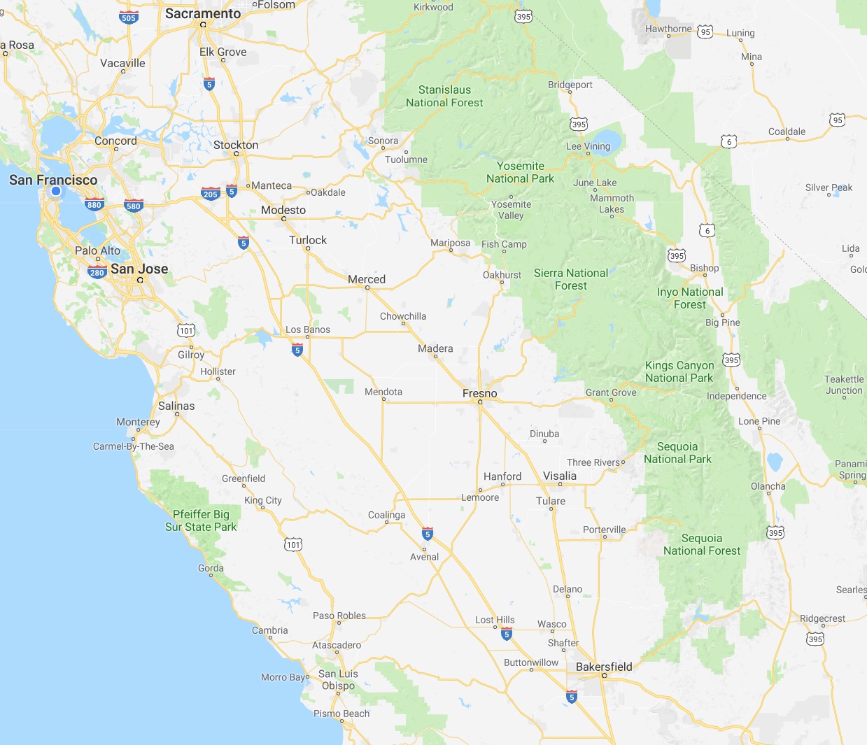


.png)


 The southeast “bulge” part of the district includes sections of Houston that lie within the I-610 loop, or “Inner Loop”. I-610 separates the downtown sections of Houston from outer neighborhoods and surrounding communities, including towns like Southside Place. It is bisected west-to-east by the new I-69 (US 59). The area where these two highways intersect would not look out of place in Los Angeles.

 Heading north and west, we come to the middle section of the district, which is largely a horizontal rectangle bounded by the mighty I-10 to the north, and which extends almost to Katy in the west. Beltway 8, also known as the Sam Houston Parkway/Tollway, bisects this segment of the district. Just to the west of the beltway are the Briarforest neighborhood and the ominously named Energy Corridor. Not surprisingly, several major energy corporations have operations in this area, as do several other businesses. The Buffalo Bayou – we at CatSynth are still not entirely sure what separates a bayou from a river – cuts through the district. It was subject to major flooding during Hurricane Harvey. In addition to the bayou itself cresting at record levels above flood stage. releases from the Barker Reservoir caused severe flooding in adjacent low-lying neighborhoods. We have sources that have informed us that the floodwaters in the Energy Corridor area were most unpleasant.

 The final section of the district cuts an inverted “L” between State Highway 6 and State Highway 99, the outermost loop around Houston, bounded on top by US 290. In all, the district has an odd shape indeed, but not so odd when one considers the tradition of gerrymandering, an art which has been taken to new heights by Texas’ Republican-controlled state government. Its shape has long preserved it as a safe Republican district – it has elected Republicans to Congress consistently since George H.W. Bush in 1966. But the city and surrounding area have been changing, and it is seen as vulnerable to flip to 2018.
 We start in New Orleans, which I visited in November of 2006, during the recovery from Hurricane Katrina. Coming in from the airport on I-10 we approached the downtown. The highway comes close to the Superdome and the downtown buildings. A large interchange connects to Business US 90, which heads over the Mississippi River via the Crescent City Connection. It was good introduction.


 I did set aside some time to see what had become of the Lower Ninth Ward. In a rented car, I headed east on Claiborne Avenue (LA Highway 39) and crossed over the canal into the district.


 The river, too, is quite wide an impressive as it passes by the Crescent City – the nickname in fact comes from the bend in river as it passes by the city. We cross the river on the Crescent City Connection to the “west bank”, which is actually south here. We continue on US 90 Business and turn south onto LA 23 towards the town of Belle Chase. LA 23 crosses the Gulf Intercoastal Waterway via an old bridge and tunnel pair, and then hugs the west bank of the Mississippi to the mouth of the river.

 New Orleans continues to function as the hub for this particular virtual exploration. We next head west on I-10 and turn south onto I-310, which crosses the Mississippi on the cable-styled Hale Boggs Bridge.
 We then head north (back on the east bank of the Mississipp) via US 61 to the town of Laplace. I was disappointed to find out this was not named for the Laplace transform in mathematics and signal processing, but on the plus side it is known as the “andouille capital of the world”. And we would be remiss if we did not stop here to sample the famous and tasty sausage.


 We then cross the Mississippi again and turn south on Louisiana State Highway 1. At first, it follows the west bank of the river, but then heads southward, beginning a long parallel with LA 308 on opposite banks of Bayou Lafourche. We pass the town of Belle Rose, which I had written about

 South of Thibodaux, we turn west on US 90. The is a major highway and being upgraded to interstate standards, passing by the Bayou Teche National Wildlife Refuge as well as several towns. We turn south onto LA 329 to Avery Island. This actually is not an island at all, but it is a salt mound that rises in an oddly circular fashion from the flat landscape. It is most known for being the home of Tabasco hot sauce. We at CatSynth are of course fans of all things hot and spicy, and so visiting this factory and a tasting session would be in order.


 We then come to the city of Lafayette, where we cross I-10 and continue northward on I-49. The area along the highway was part of an ancient flow of the Mississippi that apparently was wider and further west than it is today. Heading northward, the wet environment of southern Louisiana gives way to a drier landscape. Via LA 1 we come to city of Natchitoches, which has the feel of an older historic town.
 We continue north on I-49 to its end at I-20 near Shreveport, the third-largest city in the state. The bypass highway I-220 spans nearby Cross Lake on a graceful modern bridge. The view from below with the arches is an interesting optical effect.


 We begin where we left of in
 The shapes and textures of the rock formations and the sparseness of the landscape are what attract me to the southwest. The unique combinations of climate, water and rock composition lead to this landscape, and individual varieties of rock (many of which are different types of sandstone) lead to the distinctive shapes in different locations. Sometimes the most interesting can simply be found on the side of the road. But that does not detract from the many iconic parks in this state. Indeed, if we continue on US 160 west to its terminus at US 89, and then further west along State Highway 64, we come to the most iconic of all, the Grand Canyon.


 We head south from the Grand Canyon on US 180 to I-40 near Flagstaff. We take I-40 east to another of Arizona’s iconic locations, the Petrified Forest National Park. The eponymous petrified trees were created by combination of trees and minerals that were deposited over long periods of time and the gradual replacement of the organic matter with minerals. The relatively soft and easily eroded sandstone have left a surprisingly large number of these artifacts in one location. The extreme erosion patterns of the area also gave rise to the colorful formations of the Painted Desert.

") Leaving the park, we turn back west on I-40 to Flagstaff, and then head southward on I-17 towards the Phoenix metropolitan area and a very different Arizona. But along the way, we pass by
Leaving the park, we turn back west on I-40 to Flagstaff, and then head southward on I-17 towards the Phoenix metropolitan area and a very different Arizona. But along the way, we pass by 
")


 Heading back west on I-10, we switch to I-8 through the southwest corner of this southwestern state. We turn south on State Highway 85 through relatively empty but rocky landscape. Highway 85 intersects with 86 at the small town of Why, named for the “Y” shape of the original intersection of the two highways. Because Arizona law required location names to have at least three letters, the name “Why” was used instead of “Y”. Continuing south on 85, we eventually reach Organ Pipe Cactus National Monument.


 Apparently “fundamental values” don't include keeping the streets free of litter. These flyers were scattered all over the sidewalk, and probably made a nice paste in the rains on Monday.


 Our ultimate destination was the city park, home to the


.jpg)