
Tag: street
-
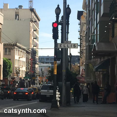
Ellis Street, San Francisco
Looking westward out from my office in San Francisco, I can see the entirety of Ellis Street, heading from downtown towards the interior hills of the city. Recently, I finally got a chance to walk the street from one end to the other.

Ellis Street is a relatively modest east-west street, but like many others in this city it traverses a diverse cross-section of terrains and neighborhoods. It begins at the intersection with Market Street and Stockton Street, shown in the photo above. At the corner is the San Francisco’s flagship Apple Store. The large construction project that has taken over the intersection is part of the new Central Subway project, in particular, a series of tunnels that will connect the existing Powell Street BART and MUNI station to the new line that goes up Stockton Street.
At ground level, we can see the mixture of tall buildings, hotels, restaurants and tourist places that dominate the blocks around Union Square.

The street is an exercise in contrasts. As we move just a couple of blocks westward, the cityscape gives way to older ornate buildings house boutique hotels, lounges, dive bars, massage parlors, youth hostels, and apartments of long time residents trying to hold on in a changing and increasingly unaffordable city.

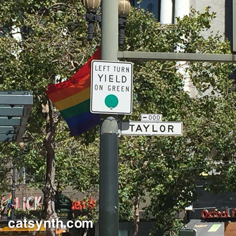
Heading into the heart of the Tenderloin (“TL”) we cross Taylor Street, which we wrote about this summer. The neighborhood has its reputation for being sketchy and having among the last concentrated pockets of poverty in the city, but the diverse neighborhood contains beautiful architecture and a wide range of people and interests.

Friends live here. There are cultural institutions here, such as the “509 Annex” of the Luggage Store Gallery where the regular Outsound New Music Series was temporarily hosted (it is now back at the main LSG building on Market Street). A couple of blocks south is the new home of Counterpulse, an experimental performance arts organization. Glide Memorial Church is a veritable institution at the corner of Ellis and Taylor that serves many in the neighborhood and beyond.
The social and architectural landscape again changes dramatically as we approach Van Ness Avenue, one of the main north-south boulevards in the city. It is lined with both tall (and expensive) apartment buildings as well as quite a few car dealerships.

Heading west from Van Ness on Ellis we continue up an incline to Cathedral Hill. Not surprisingly, there is a cathedral here: specifically St. Mary’s, a beautiful gem of modernist architecture. They also have a huge modern pipe organ and I have heard several concerts there.

Several of the apartment buildings in these blocks are quite tall, and remind me more of 1960s/1970s New York City apartments than those typically associated with San Francisco. I particularly like this cylindrical building.

Continuing westward, we enter a more low-rise residential neighborhood, and the first of a few continuity gaps in Ellis Street. It stops at block of schools anchored by Rosa Parks Elementary School before picking up again a block later.

This section of the street has quite a few gaps, actually, some of which are probably from the redevelopment of the Fillmore District. Indeed, Ellis is mostly pedestrian walkways at its intersection with Fillmore in the middle of the “Jazz Heritage District”. A block south is the building Fillmore Heritage Center that housed the ill-fated San Francisco branch of Yoshi’s.

It still has a restaurant and concert venue under various managements, as well as the larger-than-life photos on its facade.
When Ellis Street resumes two blocks to the west, it is a smaller, treelined residential street with pretty two-story residences of the classic San Francisco style.

The next large crossing is Divisadero. I have never quite figured out exactly what it is that Divisadero is dividing.

In recent years Divisadero has been a destination street in itself. I have done a bit of photography here a few blocks south, and had one of my photos from that set displayed in a show at Rare Device.
Just past the intersection is the final uphill block that I had been able to see from the office window.

It is the steepest block of the street, and the houses reflect that. This is a rather archetypical San Francisco street scape.

Ellis Street ends at the top of the rise at an unassuming intersection with St Joseph’s Street.

St Joseph’s is one of several streets here that is confined to the small hill neighborhood of Anza Vista. Over a century ago, this area was a large cemetery. All the plots have long since been moved to Colma, and it is now a fancy hilltop neighborhood whose apartment buildings and houses look more like the Berkeley hills or Daly City than the traditional parts of San Francisco.

The architectural dissonance is not surprising as Anza Vista was developed after World War II.
The walk was quite a nice one, not too long or strenuous and it was a lovely warm autumn day. But I was ready for a break, and caught a 38 Geary Express MUNI back downtown and plotted future walking adventures for the city.
-
Taylor Street, San Francisco
My exploration of the city includes walking some longer streets in their entirety. A couple of years ago I posted a report from my epic walk of 17th Street from east to west. Today we look at my walk of Taylor Street from south to north through the city.

In the map, Taylor Street is a deceptively straight road heading from Market Street downtown to Fisherman’s Wharf. But as with many of the older streets in San Francisco, the simplicity of the straight line belies the complexity of the terrain it follows and diversity of neighborhoods, people and architecture along the way.

Taylor Street begins at a five-way intersection with Market Street that also includes Golden Gate Avenue and 6th Street. The Luggage Store Gallery is close to the intersection, as was the temporary space for the Outsound series where Pitta of the Mind performed in February. It also one of grittiest and grungiest sections of the city. It has cleaned up significantly even since the time I moved here almost eight years ago. And while some of that is welcome, I do worry that the area is ripe to be turned into something more bland and vapid, akin to the newer Mission Bay developments, even if some of the building facades are preserved. That would be a tragedy. Walking up the first few blocks of Taylor into the Tenderloin district, one sees a cross section of grit and grunge and stylish old buildings, and a wide range of people that make up the life of a city.

There are many alleys and side streets throughout this part of the city. Here we see Adelaide Street, which was renamed for Isadora Duncan, the pioneer of modern dance. Her family lived in a house nearby on Taylor street.

As we approach Nob Hill, the street takes a steep turn upward. The roadway narrows, parking becomes perpendicular, and the sidewalks have embedded staircases on this block.

The architecture and character of the neighborhood is changing as well. We are entering one of the older affluent neighborhoods of the city. There are many of the classic bay-windowed buildings that continue up from the base of the hill, but also some larger mid-century apartments as well.
At the crest of the hill, Taylor Street crosses California Street with its cable car lines.

On one corner is Grace Cathedral, while on the other side are this large classic 1960s-style apartment buildings that remind me of New York. The park across from the cathedral is very stylized and manicured, more a turn-of-the-20th-century garden than a contemporary urban park. If I want some exercise and nice outdoor spot for lunch, I should come up here.
Continuing north, he street veers downward, but then after a dip it turns upward again as it ascends the even steeper Russian Hill.

As we ascend the hill, we pass over the Broadway Tunnel, which carries the main Broadway as a limited access road underneath the hill to Van Ness Avenue. A side street continues up the hill to meet Taylor on top of the tunnel, providing spectral views of North Beach, Chinatown and the Financial District.

Readers may recognize this view from the more stylized version in a recent Wordless Wednesday photo.
Up the steep hill, one sees more of the modern tall apartment buildings. Again these remind me of some of the apartments on the steep hillsides in the Riverdale section of the Bronx.

As we descend the north side of the hill into North Beach, the buildings become more of the classic San Francisco style, but a bit more pitched and in brighter colors than they were further south.

Along this incline, I discovered another interesting alley.

The sign marking Redfield Alley is one of the older embossed models that one rarely sees any longer. It uses similar type and the same color scheme as the contemporary signs, so it is probably from the 1950s or 1960s. The alley itself narrow opening to a green space. It feels more like a European city than the typical American city, but of course San Francisco is not typical of cities in this country.

At the base of the hill, Taylor crosses Columbus Avenue. The Powell and Mason cable car line turns onto Taylor, ending at cul-de-sac about a block away.

But this is not the end of Taylor Street. It’s just an interruption for the terminus of the cable-car line (why that line ends so abruptly is a story for another time). The street actually resumes, now in Fisherman’s Wharf. It is flat here, lined entirely with chintzy shops and choked with tourists. I see a couple of office buildings around here, and find myself curious what it would be like to have a normal office job in the middle of such a neighborhood.
Taylor Street continues across the large sprawling plaza at the north end of Fisherman’s Wharf, amidst the crowds of meandering tourists, and finally ends at an intersection with the Embarcedero along the waterfront.

I’m rarely ever up here, so it’s a bit of a novelty. But the disorganized slow-moving crowds of people are not very comforting, so I catch a vehicle back home. It certainly an interesting walk to see all the changes in space and time along this street. And there will be more such excursions to talk about.
