Our “Primary Highways” series continues with a visit to Colorado. This edition is a bit different, in that I trace a family trip from a great many years ago, but insert more contemporary interests along the way.
 We initially entered from the northeast on I-76. The road was relatively straight here amidst softly rolling hills of the High Plains. The landscape is dotted with farms amidst open grassland. The Rocky Mountains appear to rise from the plains quite suddenly, as does the city of Denver.

[By Hogs555 (Own work) [CC-BY-SA-3.0], via Wikimedia Commons]

 On that original family trip, we did not actually stop in Denver, but here we will do so. We turn south on I-25 along the edge of downtown Denver, passing through the interchange with I-70 known as “The Mousetrap.” We exit with US 6 which is surprisingly enough Sixth Avenue in Denver. Actually, it’s a freeway, the “Sixth Avenue Freeway.” Heading east in the freeway, it empties out onto city streets near the Santa Fe Arts District. A quick look at the websites for the galleries along the corridor suggests a relatively conservative selection, though I did see some interesting things from Sparks. Further north we find the Denver Art Museum.

[By Archipreneur (Own work) [CC-BY-SA-3.0 or GFDL], via Wikimedia Commons]
This building, which is just part of the museum, is designed by Daniel Libeskind, who also designed the Contemporary Jewish Museum in San Francisco and the plan for the new World Trade Center complex in New York. The shape of the building is intended to reflect the peaks of the Rocky Mountains, although such angles appear quite often in Libeskind’s architecture. In front of the museum, we also find once again another sculpture by Mark di Suvero, who we have encountered before in this series. This one is called Lao Tzu. The museum currently has an exhibit of Garry Winograd photography that I wouldn’t mind seeing.
 We leave Denver on I-70 and head into the mountains, on one of the most spectacular stretches of interstate highway in the country. At the Continental Divide, there are two options. One can stay on I-70 through the Eisenhower Tunnel, or take a detour on US 6 up through Loveland Pass. We opted for the latter on that original trip, with spectacular views of mountains in all directions, and a chance to walk on a patch of hardened snow and ice…in August. Not surprisingly, it was quite cold. I don’t have any pictures from that trip, but here is what the pass looks like today:

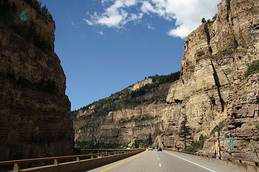
Further west, I-70 meets the mighty Colorado River and winds its way through Glenwood Canyon, which was my introduction to the southwest with its distinctive colors and rock formations. The difference from the eastern side of the Rocky Mountains and the peaks is dramatic. And while I loved the forested mountains, there is something personally compelling about the sheer red rocks. The highway itself is also quite a marvel, both in terms engineering and aesthetics as it attempts to be both functional and blend with the landscape.

[By Patrick Pelster [CC-BY-SA-3.0-de], via Wikimedia Commons]
Along I-70 in Glenwood Canyon, one passes a turn off for a place called No Name. The community of No Name supposedly did not receive its name (or lack thereof) until the coming of I-70, when it was assigned to the exit because the area lacked a formal name. There is also No Name Creek and No Name Canyon, and a No Name Tunnel on the highway.

 I-70 and US 6 descend from the Rocky Mountains into the town of Grand Junction, where they meet US 50. One can exit the interstate here and travel on State Highway 340 through Grand Junction and Fruita to Colorado National Monument.

[I, Daniel Schwen [GFDL or CC-BY-SA-3.0], via Wikimedia Commons]
The formations in the monument have this distinctive bottle shape – not unique to this location, but I noticed more of them there. Another thing I noticed there was an upper layer of rock, more gray than red, then seemed to have been gone from the more well-known canyons and formations in Utah and Arizona. It was also my first chance to see the rocks up close and personal, touch them and observe the details.


 From there, we took I-70/US 6/US 50 west into Utah. But, we later reentered Colorado from the Four Corners along US 160. The quiet and stark southwestern landscape particularly appealed to me then and still does now. We then headed north on what was then US 666 (the “Devil’s Highway”), but has since been renumbered as US 491. Honestly, I wish they kept the 666 designation. But it is what it is. The two highways separate in the town of Cortez, and one can continue on 160 east to Mesa Verde National Park.

[Andreas F. Borchert [GFDL or CC-BY-SA-3.0-2.5-2.0-1.0], via Wikimedia Commons]
The Cliff Palace was is largest of the cliff dwellings in the park. The geometric shapes and layout still present in the dwelling are quite interesting. There are distinctive towers, one square tower reaching almost to the ceiling of the cave, and the round tower; and also the sunken round spaces known as kivas. One can see the parallels in these ancient structures to contemporary southwest architecture as well.
I have not had much time to re-explore the southwest in recent years, except for a bit of Arizona, so I would very much like to return to Colorado sometime soon.


