It seems that all the interest in the primary season has faded, with the outcome all be inevitable. And perhaps our primary highways series could fade as well. But I would be remiss if I did not at least cover New York. It is a different experience to try and observe one’s home state and try and condense that experience into a short road-centric article; and experience familiar places and note those that are left out, as many others have for their own states over the course of this series.
My experience of New York has revolved around New York City, “The City” which still sets my personal standard for what a city is.

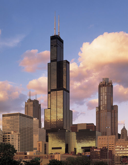
Here we see one of New York’s most iconic landmarks, the Empire State Building, from the vantage point of one of the newest landmarks, the High Line. The High Line is a public park built on an abandoned elevated rail line in the formerly industrial west side of Manhattan. It is now an integral part of the Chelsea neighborhood and the area still known as the “Meatpacking District”. I spend quite a bit of time here during my NYC trips to walk the High Line and visit the many art galleries.
And in terms of landmarks there is the Brooklyn Bridge:

In this photo, taken from the very trendy Brooklyn waterfront, we see not only the venerable bridge, but many newer buildings of lower Manhattan. The tall twisty building in the center is a new Gehry-designed residential tower. In the back we see the incomplete but already quite tall One World Trade Center, the main building in the new complex.
It is interesting to see how much the city changes every time I return, especially in comparison to what things were like in the 1980s and early 1990s. The neighborhoods that we are looking at these photos, Chelsea, Lower East Side, DUMBO in Manhattan, were nothing like what they are now. There is a bit of nostalgic charm looking at the old run-down scenes that I remember, but I know this is probably for the best.
 Another thing that makes talking about New York different from talking about other cities in this series is that there aren’t many highways to talk about, especially in Manhattan. New Yorkers take the subway. But there are still highways even in some of the denser areas of the city. The FDR Drive along the eastern edge of Manhattan is narrow and winding but offers good views of the East River and the changing skyline of the city as it passes underneath the bridges.

[By Bob Jagendorf from Manalapan, NJ, USA (Downtown) [CC-BY-2.0], via Wikimedia Commons]
 On the Brooklyn and Queens side, there is the Brooklyn-Queens Expressway, (I-278, the BQE). It zig-zags through some of the densest areas of Brooklyn on a narrow double-decker path among tall buildings. With the contemporary focus on Brooklyn, the highway has also taken on a significant identity for those who live and work there. There are even multiple art and music pieces dedicated to it, such as this piece from Performa 2009.
It is impossible to in an article like this to even scratch the surface of the city’s cultural offerings, both large institutions like the Museum of Modern Art as well as the numerous galleries and small performance spaces. So with limited space, I share with you one of my own performances in New York, at Theater Lab near Union Square in late 2011.
I could not discuss New York City without giving a shout-out to The Bronx, the borough to which I have the most family connection. Though once the “new” section of the city with fancy apartments lining the Grand Concourse, the Bronx fell into deep decline in the 1960s through the 1980s, with scenes of derelict and burnt-out buildings particular in the South Bronx commonplace. Charlotte Street perhaps was the most infamous of all such scenes.

[By User Incantation on en.wikipedia [GFDL or CC-BY-SA-3.0], via Wikimedia Commons]
Having only seen the Bronx since the 1970s and 1980s, this is what parts of it looked like. It was just part of the landscape. And I wonder if it influenced my deep interest in the aesthetics of urban decay. But these images never told the whole story of the borough, either at its nadir or during its current rebound. The Bronx has long been home to respected institutions like the Bronx Zoo and Wave Hill, and newer cultural gems like the Bronx Museum. The museum is part of the revitalization of the corridor along the Grand Concourse in the central and south Bronx.

[Wave Hill]

[The Bronx Museum of the Arts.]


 The Bronx is bisected by Interstate 87, the Major Deegan Expressway, which travels with length of the borough south to north, passing by Yankee Stadium. As it crosses the city boundary into Westchester County, I-87 becomes the New York State Thruway. The Thruway cuts through the southern part of the county before meeting I-287 and crossing the Hudson River on the Tappan Zee Bridge.

[By Sev! on Flickr [CC-BY-2.0], via Wikimedia Commons]


 This is the Hudson River Valley, known for its scenery and for inspiring the “Hudson River School”. The paintings may look rather trite and dated now, but the scenery that inspired them is still quite spectacular. One of the more dramatic points along the river is the Bear Mountain Bridge, which carries US 6 and US 202 from Westchester on the east side to Orange County and Bear Mountain State Park on the west side, spanning large hills on either side. It also connects up NY 9D on the east and US 9W and the Palisades Interstate Parkway on the west.

[By Ahodges7; cropped by Beyond My Ken (talk) 19:13, 27 June 2010 (UTC) (Own work) [CC-BY-SA-3.0 or GFDL], via Wikimedia Commons]
 On the west side of the Hudson, one can continue north on the Thruway to Albany, the state capital. However, on the east side, one could take the scenic Taconic Parkway. It begins in suburban Westchester County just north of the city and not far from where I grew up, and then continues north through picturesque rural landscape for the remainder of its route. It is in fact the second-longest continuous road listed in the National Register of Historic Places after Virginia’s Skyline drive.
")
[By Phillip Capper from Wellington, New Zealand. Cropped and color-corrected by Daniel Case 2009-12-31 prior to upload (Taconic Parkway, New York, 7 Nov. 2009) [CC-BY-2.0], via Wikimedia Commons]
In Albany, we turn onto I-787, which parallels the river through the downtown. This circle-stack interchange connects to US 20 and to the Empire State Plaza.


[By Foofy at en.wikipedia ([1]) [CC-BY-SA-1.0], from Wikimedia Commons]
 The Empire State Plaza, conceived and built by then-Governor Nelson Rockefeller, is a huge government-building complex built and arranged in the futuristic international style of the 1960s, a bit like Brasilia. As a result, I am quite fond of it. Nearby along US 20 is the State Capitol building, which is quite different from most others. It is not the Classical style with columns and a large dome or rotunda, but instead looks more like a rich family mansion that one might find in New York in the 19th century. It is a mixture of Roman, Renaissance and Victorian styles all put together.

[By UpstateNYer (Own work) [CC-BY-3.0], via Wikimedia Commons]
 From Albany, one can continue on I-87 north towards the Canadian border. Along the way, the highway passes through the Adirondack Mountains. In the northern part of the Adirondacks, one can leave the interstate for smaller roads like Highway 86 through the mountains to Lake Placid of Winter-Olympics fame, and nearby Whiteface Mountain.

[By Mwanner (Own work) [CC-BY-SA-3.0 or GFDL], via Wikimedia Commons]
 Meanwhile, the Thruway continues west from Albany with I-90, through many of the other cities that dot western New York, such as Syracuse and Rochester, passing north of the Finger Lakes. The longest is Cayuga Lake. On the south end is the town of Ithaca, home of Cornell University whose campus is on a hillside overlooking the lake, and whose official school song references the lake. Near the northern end of the lake is Seneca Falls, a famous location in the history of women’s rights in the United States. From Seneca Falls, we can also follow the Erie Canal westward. The canal, which was an important transportation route in the nineteenth century, runs largely parallel to the present-day Thruway. It is known for its complex series of locks, such as these at the appropriately named town of Lockport.

[By Leonard G. at en.wikipedia [see page for license], from Wikimedia Commons]
 The Erie Canal and the Thruway continue westward to the city of Buffalo. We leave the main Thruway and continue on I-190 towards the downtown on the shore of Lake Erie. It is the second largest city in New York State, but I have yet to visit it. It’s location on the edge of the Great Lakes and its industrial past make it seem much closer to the cities of the midwest, such as Cleveland and Detroit, than to the rest of New York. Indeed, one of the city’s landmarks, Buffalo Central Terminal reminds me a bit of Michigan Central Station in Detroit: a once grand art-deco station that has been abandoned and fallen into disrepair.

And yes, Buffalo wings do come from here.
We can head north from Buffalo on I-190 to Niagara Falls.

[By Victor Ip (Own work) [GFDL or CC-BY-SA-3.0-2.5-2.0-1.0], via Wikimedia Commons]
This image contains the smaller American falls, with the larger Horseshoe falls off frame. Next to the falls is the Rainbow Bridge, which connects to Canada, and concludes our trip to New York. Even as I finish writing this, I think of all the comments I could write about what was missed in this brief trip. But I know I will be writing about New York again in the future.


 In the eastern section of the capital, we encounter aptly named “Badger Interchange”, in which no fewer than three major interstates converge, I-90, I-94 and I-39. The interchange also includes state highway 30, a short freeway that connects to downtown Madison.
 Highway 30 ends at US 151, which traverses the isthmus that holds downtown Madison and separates lakes Mendota and Monona. I don’t know of too many other cities concentrated on an isthmus like that. Certainly, the location between the two lakes makes for interesting views and architectural opportunities. Consider this view from Lake Monona featuring the State Capitol building book-ended symmetrically by large buildings and standing behind Frank Lloyd Wright’s Monona Terrace.
 It of course did not take long for us to encounter a building by Frank Lloyd Wright, a native of Wisconsin. His summer home and studio, Taliesin, is in Spring Green, west of Madison. We take US 14 west from the capital through a green hilly landscape – it’s not hard to see why this might been inspiring for Wright’s prairie style architecture, with its use of horizontal lines and low angles that reflect the expanse of the landscape.


 I-94 continues towards downtown, passing through another large interchange, the Marquette Interchange with I-794, I-43, and US 41. It does look like a complicated tangle.


 Wisconsin does not have much shoreline on Lake Superior compared to its neighbors – in particular, Michigan extends quite a bit westward along the south shore of the lake, but it does have the Apostle Islands National Lakeshore. We can get there from Michigan on US 2, passing along the edge of Chequamegon Bay before turning north onto WI 13 along the waters edge to the Apostle Islands. In addition to wildlife and great views of Lake Superior, the islands have unusual “sea caves”, such as these at the edge of Sand Island.


 If we take I-290 west from this geometric oddity of an interchange, we come to the suburb of Oak Park. It was here that Frank Lloyd Wright began his storied architectural career. His home and studio in the town is a landmark, and there are numerous early examples of his prairie-style houses. Looking at his home and studio, one can see the elements that would be later refined in prairie style.

 Continuing south on I-57, we pass by our friend I-80 in the southern suburbs of Chicago and eventually come to Champaign and Urbana after crossing I-74 – it does seem that Illinois has a lot of interstate highways. This cities are home to the University of Illinois at Urbana Champaign, the flagship campus of the University of Illinois. It hosts the NCSA (The National Center for Supercomputing Applications) that created the first graphical web browser Mosaic.
 Before we overdose on computer history, we exit Champaign-Urbana on I-72 heading westward. (Did we mention that Illinois has a lot of interstate highways?). This view along the highway suggests just how flat the landscape is in this region, with the road completely straight.


 We head south from Springfield on I-55, on another incredibly straight stretch of highway through very flat landscape. For those who have lived among hills our entire lives, these flat plains are a novel experience. It’s not only the land, but also the sky.
 There is a significant break in the flat landscape of western Illinois along the Illinois River. Illinois Route 100 runs along the the west bank of the river amidst trees and bluffs. It then crosses a bridge and continues along the east side until the Illinois River meets the Mississippi River.
 The Great River Road continues past the end of IL-100 and into the greater St. Louis metropolitan area. As the landscape along the river becomes more suburban and then urban in St. Clair county, the road bounces around many other designations, including I-70 in East St. Louis. From here we can continue across the Mississippi to St. Louis itself, or continue southward on the Great River Road as IL-3.
 We opt for the latter, passing through towns with Egyptian sounding names until we come to Cairo, at the southern tip of the state, where the Ohio and Mississippi rivers meet. We meet I-57 again and then continue into the town itself on US 51. Cairo (pronounced KAY-RO) was once a significant center of trade along the rivers. But it has been in a long decline, and now has a population of about 2,800. Indeed, some views of the town make it look nearly abandoned.
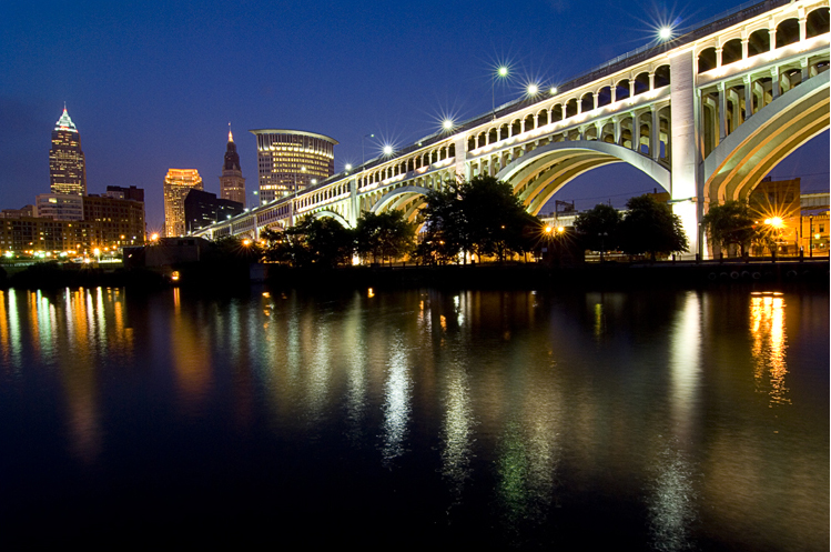


 Looking towards the lake from this bridge, one sees how closely packed the crossings are, and the diversity of shape, height, function, and level of disuse. In the picture below, we see the blue bridge carrying a major freeway, State Highway 2, beyond that a rail bridge, and in the front the ruins of the older Detroit Avenue viaduct.


 We depart Cleveland continuing on I-90, and then switch onto I-71 to journey diagonally across the length and breadth of the state. It winds through the suburbs, crossing many other highways before intersecting our friend I-80, which runs across the state as the Ohio Turnpike. The Ohio Turnpike is familiar from numerous cross-country trips, with the rolling hills and suburbs giving way to a much straighter road over flat terrain and farmland as one heads west. But in this instance, we continue south on I-71 towards Columbus, the state’s capital and largest city.


 Columbus is in the middle of the state, and without much to get in the way it has developed the “standard” set of ring roads we see in many cities around the world: an outer beltway (in this case, I-270) and an inner belt around the downtown (a combination of I-70, I-71, I-670 and State Highway 315).


 I did actually travel to Seattle through this interchange a few years ago, while
  To the west of I-5 is State Highway 99, the Alaskan Way Viaduct. This is a double-decked elevated highway along the industrial waterfront, and actually seems quite interesting, both looking at it from the bay and for the spectacular view of the city and bay that one would see while riding it.


 We came into Montana at night on

 Our trip back from Montana took us through South Dakota on