Pick Your Poison: Road Travel in California

We at CatSynth love traveling and exploring our adopted home state.  This includes day trips from the Bay Area as well as longer adventures.  But one thing remains a bit of a challenge.  For much of the state, the main highways are primarily north-south, with very few east-west routes.  One chooses one of the long-haul north-south highways, California 1, US 101, I-5, California 99, or US 395 and is pretty much locked in with only a few options for efficiently traveling east to west.  There is I-80 in the middle north, California 152 or California 46 from the coast through the Central Valley and California 58/I-40/I-15 further south.


North of Sacramento, east-west travel becomes even more difficult, with routes like California 20 and California 299 being relatively rural and windy for much of their length.  The end result is that most of our trips – especially single-day trips heading north – are forward and back along one of the main north-south routes unless we have extra time or necessity to use the smaller east-west roads.

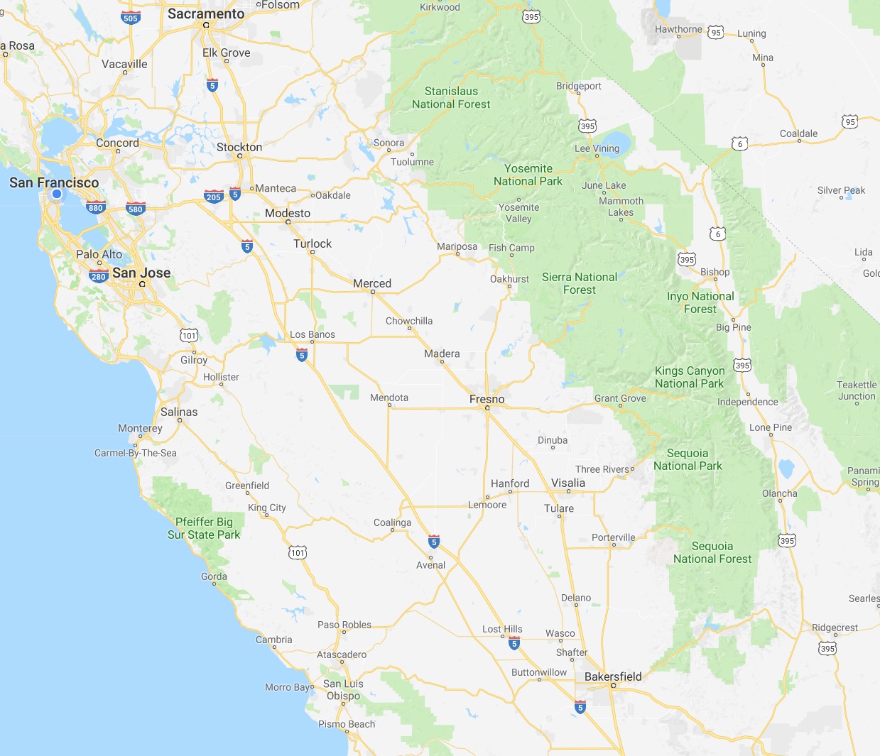
This north-south bias can be seen in an almost self-similar way when zooming in on the extended Bay Area.  South of San Francisco, there is California 1, I-280, US 101, I-880, I-680 and then not much at all until one gets to I-5 in the Central Valley.

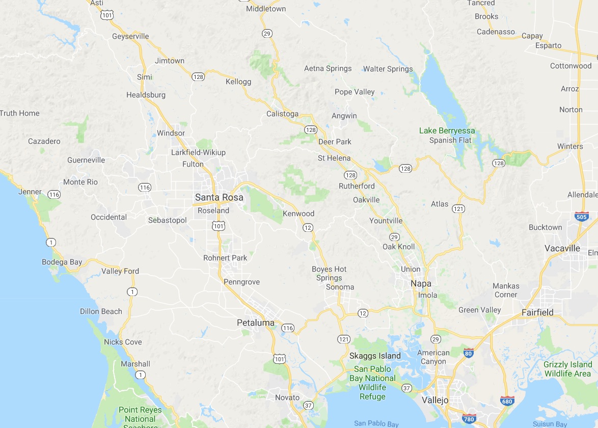
In the North Bay and wine country, a similar pattern appears with CA 1, US 101 and CA 29, with another large gap until I-505 and I-5.  We have made use of east-west roads like CA 128 to get between them as in our recent wine-country trip that featured Elsie the Library Cat.  But this is a long detour.

This north-south axis may be frustrating at times (especially the further north one gets), but there is nothing particularly sinister about it.  It’s all a matter of Calfornia’s geology.  The interface of the Pacific and North American plates that give us our reputation for earthquakes also lead to long bands of north-south mountain ranges and valleys.  The Sierra Nevada may be the most dramatic, but it is only one of several that form vertical stripes, with the Central, Sacramento, Salinas, and Napa valleys in between.  The San Francisco Bay can be seen as another such valley in a way, with shallows bounded by high hills running north-south.

The exception to the “north-south rule” can be found south of the San Gabrial mountains and into the desert.  From Los Angeles and San Diego, one can easily travel east-west to the desert towns and to the Arizona border on I-10 and I-8, with a network of other east-west freeways in between.  It is definitely a different experience traveling down there once one gets over the Grapevine or the Tehachapi Pass and into the southern realms.  As for the rest of the state, there is no escaping the geographic reality, so it is best to embrace it, and even enjoy it.

Interstate 5, California: The Road to (and from) NAMM

At least since 2010, all of my trips to NAMM have been road trips, heading east from San Francisco on I-580 to meet Interstate 5 for the long trek south through Los Angeles to Orange County.

CatSynth on Interstate 5

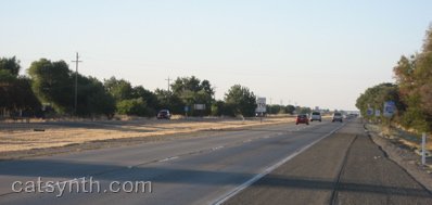
I-5 takes a more direct route through the sparsely populated western side of the Central Valley, compared to CA 99 (former US 99) that connects the major towns and cities of the region, including Fresno and Bakersfield.  The small communities that one does pass are related to travel on the interstate itself or to the farms and orchards that dominate the landscape between stretches of emptier space.
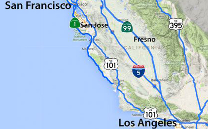
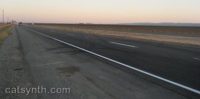
It is a long trip, and one that I know many people would find boring.  But for me, it is something I look forward to, an integral part of the experience along with the show itself, the after-parties and all the other little adventures. This year there was the added fun of testing out Highway☆ on the road trip, but even without that heightened sense of purpose, it is simply an enjoyable “flow experience.”  Once over the Altamont Pass and into the Central Valley, stresses begin to fade as the mostly straight line of the road and the low stimulation of I-5 takes over.  It may seem “empty” but there is still is just enough detail along the route to provide balance.  After many years, I have come to know just about every major junction and many of the other details, such as the names of the small communities along the highway.  By the time I arrive in the Los Angeles basin, I am recharged, enough to even remain unfazed by the notorious traffic!

The return trip along a nearly identical route is similarly an opportunity for psychic calm and flow after the nonstop overstimulation of NAMM (I do spend a half day after the show either with friends or at a museum as part of the decompression process before getting back on “The 5”).  This year was no different, as I headed back with a tailwind and sense of optimism.   Life seemed calm, free, but also filled with curiosity and excitement about professional opportunities in technology, music, and even travel.  That feeling lasted into our arrival back in San Francisco, at least until my second bout of this year’s awful flu kicked in, along with some other stressful local responsibilities.  One of the mental exercises to help through the ensuing week was to focus on how my mind and body responded positively to the I-5 trip (and to the many tendrils of travel in and around L.A.) and thought experiments on how to capture that sense of enjoyment and calm even when not traveling down a straight and empty stretch of road.  I come back again to flow experience and how much that seems to be a product of solitude for me, but it can also come in playing together with musicians at the highest levels.  And then there are situations where flow is stymied or non-existent.  It is important to recognize both, and I hope to explore these topics more in upcoming articles.

See more of Interstate 5 in California and many other fine places across North America in our Highway☆ app, available on the Apple App Store and Google Play Store.

Highway☆ on Apple App Store .   Highway☆ for Android

Fun with Highways: Northern California along I-5

As summer winds down, we start to look back the many little road adventures that dotted the season. The largest and last of these trips, of course, was to Portland, which included a large stretch of northern California.

We begin on I-505, which heads north from I-80, bypassing Sacramento.

20130809-IMG_8527

I-505 is a completely straight, flat, stretch of highway. This is pretty much true of the surrounding landscape as well, but the texture and details against this blank canvas can make for some interesting photos.

20130809-IMG_8528

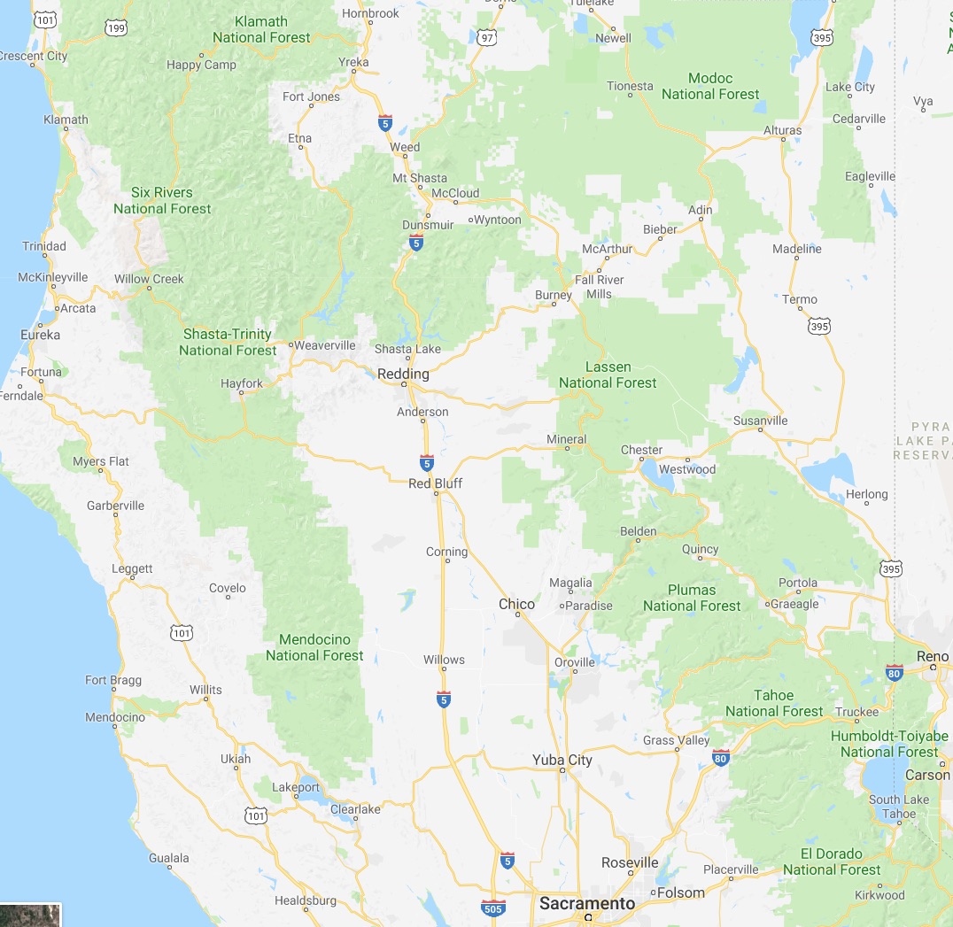
I-505 merges into I-5, which continues northward through more of the relatively flat landscape, repeatedly crossing the Sacramento River in the process. Eventually we come to the city of Redding at the northern end of the Sacramento Valley. On my return trip from Portland, I finally had a chance to stop in Redding and visit the Sundial Bridge. This modernist architectural gem spans a wooded section of the Sacramento River completely, a world apart from the town of Redding itself or the strip malls and shopping centers that line the highways. Here, clean modern lines contrast with the natural forms of trees and running water.

20130812-_MG_9848

20130812-IMG_8686

The Sundial Bridge turned out to be a great subject for abstract photography (you can see another shot in an earlier Wordless Wednesday). It was also quite crowded with families and groups, something to keep in mind should I ever want to use it as a setting for a more formal photo shoot.

North of Redding, I-5 climbs into the southern Cascades towards Mount Shasta. The highway here is quite scenic, but also narrow, winding, and treacherous. Eventually it opens up as one passes Mount Shasta and approaches Black Butte.

20130809-IMG_8534

Black Butte is a satellite cone of Mount Shasta. It has a distinctive pointy shape and largely barren rocky texture, both of which make it quite prominent in the landscape. The highway curves around its edge, providing a close-up view.

Historic_US_99CA_265US_97_CA
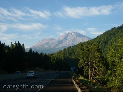
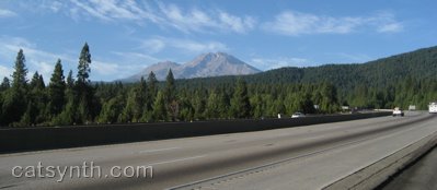
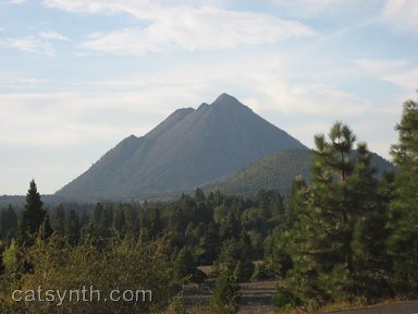
After passing Mount Shasta and Black Butte, I-5 descends into a wide valley, passing by the town of Weed, whose welcome sign is a popular backdrop for photographs. This is the start of US 97, which heads northeast towards Klamath Falls and central Oregon as I-5 continues due north through the Cascades towards Portland. The main street in Weed is also Historic US 99. The part of the historic route which returns to I-5 is now California Highway 265, one of the shortest in the system.

20130809-IMG_8535

20130809-IMG_8536

From here, the valley descends and opens further, and the landscape becomes surprisingly desert-like. We pass the town of Yreka, where I did not get a chance to stop, but might on a future trip because of some idiosyncratic road-geek things. Finally, the highway climbs upwards again towards Siskiyou Summit, just north of the Oregon-California border and the highest point on all of I-5 at 4,310 feet (1,310 meters).

Fun with Highways: Portland

My trip to Portland for BPOW included becoming acquainted with its streets and highways (and mostly not getting lost). The city is largely defined by the Willamette River, which bisects the city in eastern and western halves, and a series of bridges over the river connecting the two sides:

20130811-IMG_9812

OR_99EI-84The above photo is looking north at the Burnside Bridge, which carries one of the city’s main thoroughfares. The vantage point is from the center of the Morrison Bridge, which combines traffic entering and exiting I-5 with city streets, walkways and bike paths. It seems to part of the theme in Portland that all these different modes come together and coexist along single routes. Looking towards the east side, the bridge connects to I-5 and I-84, as well as state highway 99E (Martin Luther King Avenue) and Water Avenue.

20130811-IMG_9813

I-5 runs along the east bank of the river. But it also runs with bike and walking paths and a greenway. The highway, park, water and industrial zone behind them all co-exist.

20130811-IMG_9815

I like the way Portland has chosen to co-exist with its older industrial infrastructure and highways as it plans green spaces and alternative transportation options. It is in sharp contrast to San Francisco, which can’t seem to tear down its highways and raze its gritty industrial areas fast enough. There is a beauty and attraction in preserving them while making the city for livable and environmentally friendly. The area around Water Avenue in the “Industrial Southeast” section of the city particularly retains this character. I had briefly seen it during my 2007 trip with the band that would later become Reconnaissance Fly, and for the BPOW trip I made sure to set aside time to explore. Much of the neighborhood is below the bridges and viaducts, but in between it opens up into spaces with larger warehouses.

20130811-IMG_8640

20130811-IMG_8637

It can be quite colorful if you know where to look.

20130811-IMG_8641

Heading north at ground level, we follow the viaduct until we get to a rather nasty looking interchange. This is the northern terminus of I-405, which loops around downtown on the west side.

20130811-IMG_8613

20130811-_MG_9794

There are also several city streets and rail involved here in ways I can’t quite figure out. It also oddly frames the rose skyscraper that dominates downtown.

20130811-_MG_9787

From here, we head north on 99E to the northeast section of the city. The industrial character gives way to a neighborhood of mixed residential houses and small stores. It here that BPOW took place at Cymaspace. You can read the first part of my report covering the workshops here. The second half, which will cover the evening concerts, will be published soon. In the meantime, we at CatSynth recommend enjoying a beer, of which there was no shortage in any neighborhood of the city.

20130811-IMG_8588

Fun with Highways: Seattle

After New York and San Francisco, Seattle has recently been among the top cities for this site and our Facebook page. So today we are paying tribute with a visit of some of the city’s highways.

Two of the major highways in the U.S., I-5 and I-90 meet in downtown Seattle at this massive interchange:

I did actually travel to Seattle through this interchange a few years ago, while on tour with the band that would later become Reconnaissance Fly. I-5 may look wide here as it passes under I-90, but further north it felt narrow and windy, more like the highways inside New York City, with buildings on either side of us.  We took the exit for Madison Street and headed up the hill to our gig, not far from some cool-looking transmission towers (Is it weird that I actually remember these particular details?).  It was a bit of a nostalgic trip to go back and read the gig report, and see how far we’ve all come musically since then.

To the west of I-5 is State Highway 99, the Alaskan Way Viaduct. This is a double-decked elevated highway along the industrial waterfront, and actually seems quite interesting, both looking at it from the bay and for the spectacular view of the city and bay that one would see while riding it.

In some ways, it seems like the former Embarcadero Freeway in here San Francisco, including the fact that it is scheduled to also be “former” soon. Plans are to demolish the elevated highway and replace it with a tunnel, and surface boulevard that connects the downtown to the waterfront. The replacement plans seem to be as controversial as the highway itself. Both fall along predictable lines, the typical reaction of many who see a highway like this as an “eyesore”, and those who are worried about the costs of replacing it. The bored tunnel seems quite impressive, and more walkable space seems like a good concept. The replacement of the Embarcadero Freeway here with an open and walkable waterfront space seems quite successful (it was all done before my time), but I still felt a little sad seeing those last vestigial bits of the old infrastructure get demolished last year. I thought they were architecturally interesting (and photogenic). These views (courtesy of Wikimedia Commons) show the underside and details of the Alaska Way Viaduct.

Hopefully the project works out well for Seattle. Demolition began earlier this year.

Fun with Highways: Sacramento edition

This is a major interchange in Sacramento, California, where I spent most of yesterday. Running north-south along the river is I-5, while east-west is the Capitol City Freeway (Business 80 and US 50).

To the southeast of the interchange, along X street, is the neighborhood that includes Beatnik Studios, where I performed with Reconnaissance Fly at the In The Flow Festival. See our previous article for a link to a liveblog of the festival.

The nearby entrance from 16th street to the Capitol City Freeway is marked only as Business 80, and does not mention US 50.

One can follow 16th street north under the freeway to the downtown and midtown section of the city. This includes our rather dysfunctional state capital, and a scattering of fun local businesses north of N street, including Luna Cafe, which was hosting events related to the festival on other evenings. We were not there at right time to see the festival events, but we did stop in for some handmade juices and enjoyed sitting out on the sidewalk in the early evening. For those of us who live in San Francisco, a warm evening is a rare treat.

Fun with Highways: Orange Crush Interchange

This afternoon we at CatSynth avoid our responsibilities by presenting another highway interchange.

This is the so-called “Orange Crush” interchange in Orange County, CA, where I-5 and state highways CA 22 and CA 57 meet.  You can see how the three freeways converge in this USGS map:

[click to enlarge]

I actually got to know this interchange quite well during my recent NAMM trip, and ended up at one point or another on each of the highways.

There is actually an ulterior motive in doing a highway post today.  I am planning on doing a few posts on the intersection of art and highways (no pun intended).  While I have collected a few examples myself, I would welcome suggestions from readers.

Primary Highways: Oregon

Our series returns to the west coast, and to a state I know from personal experience. I have traveled through the western part of Oregon multiple times. It is a state that at first glance has much in common with northern California, politically and geographically, but has its own unique characteristics.

Traveling north on I-5, one crosses an arbitrary line the separates the spectacular landscape of far-northern California from the spectacular landscape of southwestern Oregon. The highway weaves through the mountains and valleys of the Cascade Range, including numerous volcanic (or formerly volcanic) peaks.

At the town of Medford, one can continue north, or take a detour east on state highway 62 to Crater Lake. Crater Lake fills a caldera in the Cascade Range, and is the deepest lake the United States. It's circular shape is quite distinctive, as are its internal landmarks, including Wizard Island (the pointy island to one side of the lake), the “Old Man of the Lake“, and several volcanic formations. I had the opportunity to visit Crater Lake many years ago.

More recently, I traveled the other route from Medford, on I-5 north to Portland, while I was on tour last October.

We experienced Portland's famously variable weather. Fortunately, many of the city's attractions are indoors. This includes Powell's Books. I could have spent the whole day in the Pearl Room, which contained the art and architecture offerings, as well as their extensive rare book collection.

Portland also has abundant public art. Across from Powell's is this “brush,” a noted landmark:


[Click to enlarge]

This building brings to mind the city's nickname, Rose City.


[Click to enlarge]

These are only a few of the photos I took while on tour. Please visit the original article for more images, including the intriguing “recursive elephant” sculpture (and the hidden cat).

Portland is someplace I could see living, and indeed the idea crossed my mind during my period of unemployment last year. Ironically, it was en route to Portland that I took the fateful phone call that led to my current job and new life in San Francisco.

We also performed in the coastal town of Astoria, which can be reached by traversing the coast range or traveling along the Columbia River on US 30. This is actually the western end of US 30, which starts at a junction with our friend US 101.


[Click to enlarge]

Astoria was cool and rainy and very green, as one would expect along the northern Pacific coast. The people we met there were also very welcoming to a group of Bay Area musicians playing weird experimental music. Again, you can read more about our visit at the original tour article.

I have never been to the eastern part of Oregon, which is a very different place altogether. I am quite intrigued by the descriptions of part of eastern Oregon as a desert landscape. But it seems like one has to be very motivated to visit, as it is far less populated and less accessible via major highways. The east-west divide also seems to extend to politics, with western Oregon being more liberal in the “northern California” sense, and eastern Oregon being more conservative. I wonder how this divide is going to play, at least in the media, given the patterns of this election…

Sacramento Valley and Mt. Shasta

This is the first of several articles on my recent “grand loop” through northern California in August. Starting from the Bay Area, north through the Sacramento Valley to the Cascades (including a side trip to Lassen Volcanic Park), and then west to the Mendocino coast and back south to San Francisco.

The segment of this trip is along I-80, crossing the Bay Bridge and north through Berkeley into the towns of the “North Bay” that always seemed remote even when I was lived in the area. I-80 crosses over the New Carquinez Bridge into Solano County, ultimate towards Sacramento.

In order to head north without having to get too close to our state's capital or Arnold, one takes the short-cut known as I-505 into the Sacramento Valley. This is a largely agricultural region of fields and orchards, and it is flat. As in “how much more flat could you be? None more flat.” (Apologies to Spinal Tap).

One of the interest sites along the side of the road was this flock of sheep, doing what sheep do best, except for that one looking straight at us:

Somehow, sheep are always instant humor. I am not sure why, but it's a fact, they're just funny even when they're not doing anything. We need to confer on them some sort of hip cult status befitting their character. Baaaa!

I-505 soon rejoins the main I-5 freeway coming north from Sacramento towards the Oregon border. Somehow, I-5 manages to appear even flatter than 505:

However, such images are a bit deceiving. While the Sacramento Valley is indeed very flat, it is quite visibly bounded by mountain ranges. To the west is the inner Coast Range, and far to the east are the foothills of the Sierra Nevada range. There are also the Sutter Buttes, dubbed the “smallest mountain range in the world.”


(Click to enlarge)

Whether we are seeing haze or the infamous Central Valley pollution in this photo isn't clear (no pun intended). The Sutter Buttes are actually quite a distance away from I-5. One surprising characteristic of the Sacramento Valley, at least during this visit, was how humid the air felt, so it could easily just be haze.

Pretty much things continue this way along I-5 until one reaches Redding, the largest city in California north of Sacramento, and the gateway to the Cascades. Very quickly, the highway begins to climb into the foothills, winding its way along the sides of hills and over high valleys (one of which was flooded to create Lake Shasta). No sign of Mt. Shasta. The directions to get there includes those famous words “You can't miss it”, but a first time traveller might begin to doubt that aminst the endless steep green hills and valleys. But then, there it is. And yes, you can't miss it.

Oh, and here it is again:

Shasta is a volcanic peak, one of the tallest in the Cascades, and is distinct for being very disconnected from any other other tall peaks. About the closest I could find nearby was this peak which I simply dubbed “pointy mountain:”

“Pointy Mountain” turns about to be Black Butte, a nearby lava dome (not to be confused with Black Butte in Oregon). It is clearly visible from the town of Mt. Shasta on the other side of I-5 (town on the east, peak on the west).

It is from the town of Mt. Shasta that we take this final shot of the mountain, a little before sunset time:


(Click to enlarge)

One thing to note is the lack of snow on the mountain. Granted it is August, but I was here in August 1998 and remember seeing a lot more snow, This is probably a product of our drought in California, including relatively little rain/show this past winter. Whether or not the trend continues, and mountains like Shasta become less “snow-capped”, remains to be seen…