Fun with Highways: California 99 and 198

The ride back from NAMM is usually an uneventful straight shot up I-5 from Los Angeles towards San Francisco. But I found myself making good time, and in a mood for a bit of exploration – not to mention an opportunity to rack up more routes on my Highway☆ app – so I decided to try something different. I decided to follow California Highway 99 as it splits off from I-5.

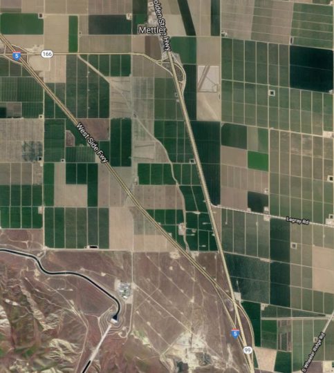
CA 99 takes a more easterly route than I-5 and connects to the major towns and cities of the Central Valley. A stretch in the northern part of the Central Valley was featured in our recent CatSynth TV Episode 99, but the southern part largely remained unexplored outside the immediate vicinity of Bakersfield (where it intersects CA 58). So much of the highway was new.

That southernmost section was, to put it bluntly, rather sad. The road is narrow, bumpy, and crowded. The landscape was dotted with a mixture of fields, run-down housing developments, and strip malls. And the sky was smoggy with an unhealthy yellow hue. But the afterglow of our most successful NAMM show to date along with the spirit of exploration gave a level of joy to the experience. At Visalia, I decided to turn off and head west onto California Highway 198.

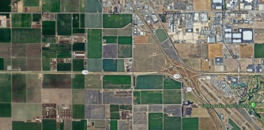
If 99 was a bit of a cluttered and bumpy mess, 198 was the opposite: a pair of smooth straight lines cutting through farmland with sparse development. It began as an expressway but soon turned into a full-on freeway in Kings County as we headed toward Hanford and then on to Lemoore, where we intersected with Highway 41 in a major interchange. A few years ago, I had seen it from the perspective of Highway 41 and mentioned it a post at that time.

There is something strangely fascinating about the island of small towns sitting at the northern edge of dry endorheic Lake Tulare. I can’t quite put my finger on it, but it is strong enough to inspire a story line and possible writing project that I work through in my mind when I have trouble sleeping at night. We will see if anything comes of it.

Past Lemoore Naval Air Station, 198 narrows to a small two-lane route, and becomes significantly less interesting. My mind shifts to the story on the radio about people whose altruism goes to extreme lengths, including a man in India who founded and nurtured a growing community for people with leprosy while putting himself and his family (including two young children) at risk; and a couple who kept adopting more and more children while having less time and attention for their older biological and adopted children. These drives can be seen as incredibly caring and generous, but I also wondered if they were a bit pathological – indeed, the seeming lack of concern for others affected as they pursued their extreme altruism seemed to be mark of a sociopath.

Heading west on the narrow section of CA 198, we approach Interstate 5 again. This is, however, a spot infamous to north-south travelers for its offending aroma. It turns out the infamous small at the Coalinga junction of I-5 and CA 198 comes from the gigantic Harris ranch and feedlot. It only got worse after turning north onto I-5, but soon enough it was behind me and a not-too-long road to San Francisco remained ahead.

See more of California and many other fascinating places in our Highway☆ app, available on the Apple App Store and Google Play Store.

Highway☆ on the Apple App Store
Highway☆ for Android

CatSynth TV Episode 99!

It’s the 99th Episode of CatSynth TV, and we have a special treat for all our readers and videos. It combines many of our interests: synthesizers, cats, experimental music and film, and highways.

Video shot along Highway 99 in California from Manteca through Stockton and heading towards Sacramento. Additional video and photography at CatSynth HQ in San Francisco.

Guest appearances by Sam Sam and Big Merp.

Original experimental synthesizer music by Amanda Chaudhary, based on melodies from “99 is not 100” by Moe! Staiano.

Synthesizers used:

  • Minimoog
  • Arturia MiniBrute 2S
  • Big Fish Audio John Cage Prepared Piano Sample Library (Kontakt)
  • Nord Stage EX
  • Mutable Instruments Plaits
  • Metasonix R-54 and R-53 2hp Cat module
  • 4ms Spectral Multiband Resonator
  • Make Noise Echophon

Pick Your Poison: Road Travel in California

We at CatSynth love traveling and exploring our adopted home state.  This includes day trips from the Bay Area as well as longer adventures.  But one thing remains a bit of a challenge.  For much of the state, the main highways are primarily north-south, with very few east-west routes.  One chooses one of the long-haul north-south highways, California 1, US 101, I-5, California 99, or US 395 and is pretty much locked in with only a few options for efficiently traveling east to west.  There is I-80 in the middle north, California 152 or California 46 from the coast through the Central Valley and California 58/I-40/I-15 further south.
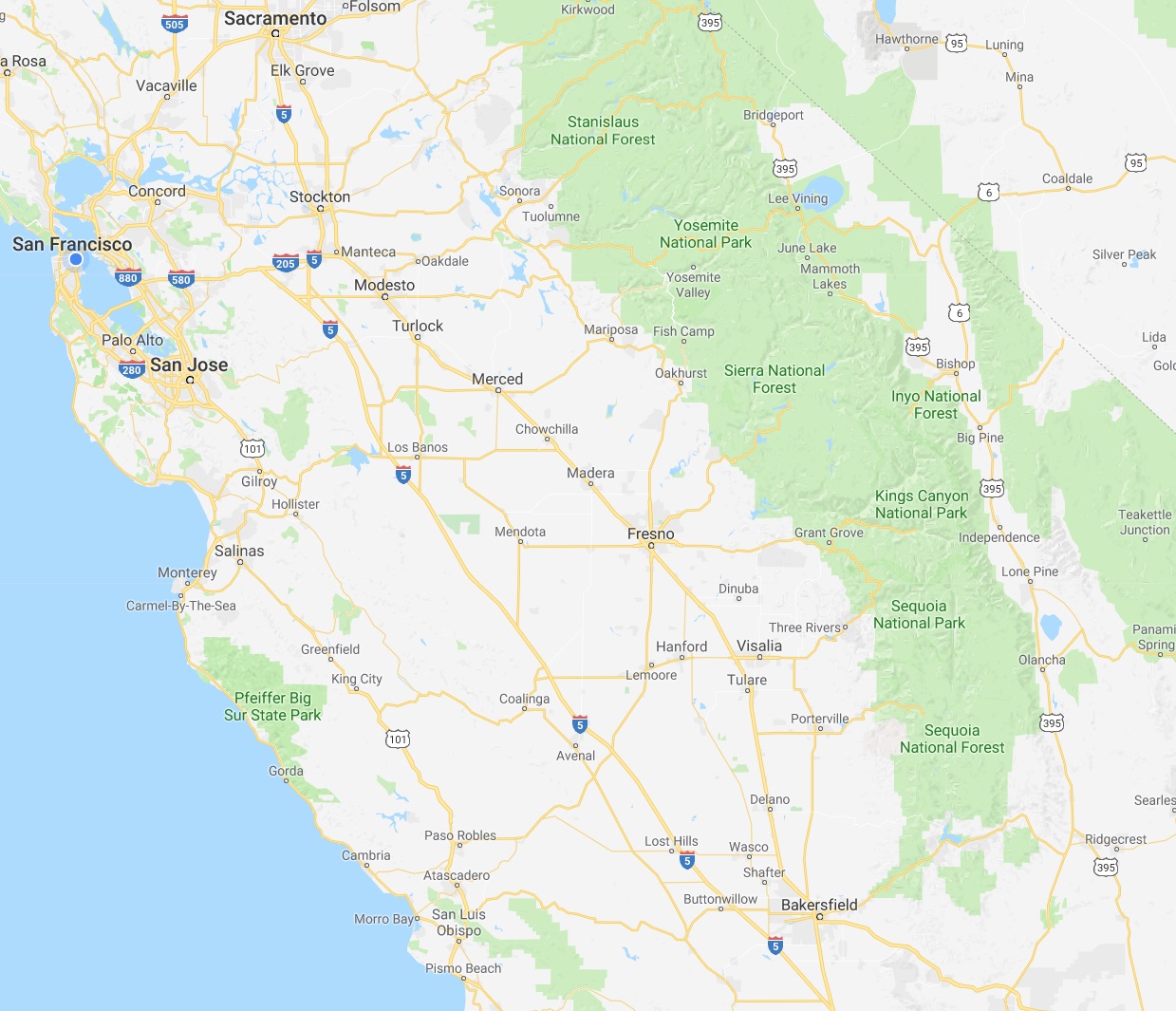
 

North of Sacramento, east-west travel becomes even more difficult, with routes like California 20 and California 299 being relatively rural and windy for much of their length.  The end result is that most of our trips – especially single-day trips heading north – are forward and back along one of the main north-south routes unless we have extra time or necessity to use the smaller east-west roads.

This north-south bias can be seen in an almost self-similar way when zooming in on the extended Bay Area.  South of San Francisco, there is California 1, I-280, US 101, I-880, I-680 and then not much at all until one gets to I-5 in the Central Valley.

In the North Bay and wine country, a similar pattern appears with CA 1, US 101 and CA 29, with another large gap until I-505 and I-5.  We have made use of east-west roads like CA 128 to get between them as in our recent wine-country trip that featured Elsie the Library Cat.  But this is a long detour.

This north-south axis may be frustrating at times (especially the further north one gets), but there is nothing particularly sinister about it.  It’s all a matter of Calfornia’s geology.  The interface of the Pacific and North American plates that give us our reputation for earthquakes also lead to long bands of north-south mountain ranges and valleys.  The Sierra Nevada may be the most dramatic, but it is only one of several that form vertical stripes, with the Central, Sacramento, Salinas, and Napa valleys in between.  The San Francisco Bay can be seen as another such valley in a way, with shallows bounded by high hills running north-south.

The exception to the “north-south rule” can be found south of the San Gabrial mountains and into the desert.  From Los Angeles and San Diego, one can easily travel east-west to the desert towns and to the Arizona border on I-10 and I-8, with a network of other east-west freeways in between.  It is definitely a different experience traveling down there once one gets over the Grapevine or the Tehachapi Pass and into the southern realms.  As for the rest of the state, there is no escaping the geographic reality, so it is best to embrace it, and even enjoy it.

Weekend Cat Blogging with Luna: Fun with Highway Signs

My eccentric long-standing fascination with numbered highways has long been reflected on this site. Here we see Luna contemplating a couple of our most recent sign acquisitions.

20140412-IMG_0611

So what exactly do we do with these? Well, besides just the human tendency to collect things of interest, I have used signs in artwork, photography, video and I am now expanding into more modes of live performance. Mostly, dealers advertise these as “perfect for your man cave”, something which does not interest us at CatSynth in any way. For Luna, they are just more strange objects that pass through her territory. And great neck scratchers.

Fun with Highways: Livingston (?)

Every so often we like to have fun with the cities and towns that appear in our Facebook Insights and Google Analytics. One town that has been appearing prominently in our Facebook page stats recently is Livingston. However, we have no idea which place called “Livingston” this actually is, so we will explore a few possibilities.

Based on the demographics of our readers and Facebook fans, it’s probably in the U.S., and it is most likely Livingston, NJ, a town east of Newark along I-280, not far from New York City.

Livingston is a medium-sized suburban town. Though its history dates back a long time (about 300 years), it was relatively sparse until automobiles and highways arrived in the 1920s. Notably, it is named for William Livingston, the first Governor of New Jersey. It is also near the Riker Hill fossil site, also known as Walter Kidde Dinosaur Park, a major paleontological site – I remember hearing about the “major dinosaur fossil site in New Jersey” a few times while growing up across the river in New York.

It could be Livingston, California, a town along the Highway 99 corridor in the Central Valley, between Modesto and Merced.

Like much of this part of the Central Valley, it is primarily an agricultural town.

It could also be Livingston, Montana, a picturesque town along I-90 and US 191 north of Yellowstone National Park.

[Image by Jonathan Haeber (http://www.terrastories.com/bearings/) via Wikimedia CommonsClick image to enlarge.]

It has that classic “old US downtown” look with mountain ranges in the background. It also seems like a relatively prosperous town (much of its economy is related to tourism). As of this writing, however, it sounds like they are at the edge of this year’s intense flooding along rivers in the U.S. and the Yellowstone River is again above flood stage as of the writing of this article. We hope they stay safe and dry! In late May, flooding on the Yellowstone River closed parts of I-90 near Livingston.

Livingston, NY is in the Hudson Valley and quite a ways north of New York City. It is considerably smaller than its counterparts in New Jersey, California and Montana.

In the strange way that I remember such things, I am pretty sure I have been through the junction of US 9, NY 9H and NY 82 (and NY 23).

Smaller yet is Livingston, Louisiana.

It is along I-12 east of Baton Rouge. I mention it because it has a gravitational wave observatory. That is cool. Gravitational waves are theoretical ripples in the curvature of spacetime that propagate as a wave – a phenomenon predicted by Einstein’s theory of general relativity but never directly detected.