17th Street is one of the longer numbered streets in San Francisco, though not the longest. What makes it unique among its peers is that it forms an almost perfect horizontal line through a large swath of the city, cutting through a variety of neighborhoods and terrains. Like reading geological strata or tree rings, it is an efficient way to explore San Francisco’s geography and history. For quite a long time I have wanted to walk the length of 17th Street. And on March 17 of this year, things lined up in terms of numbers, schedule and weather to make the perfect day for this walk.

17th Street begins at a modest corner with Pennsylvania Avenue at the base of Potrero Hill, next the I-280 elevated section. This used to be a rather forlorn block, but it has been upgraded quite a bit with the addition of a small park at the end of the street.
The street then heads westward through the flat land below Potrero Hill and crosses many of the streets named for U.S. states. Along the way one passes Bottom of the Hill, a club that I recently played at (you can read the gig report here). There is also Parkside, where I have yet to play. The architecture in this area changes between industrial and the modest wooden houses that typify San Francisco. There is also some newer condo and office development.

The street then heads uphill and underneath the US 101 freeway. From here, one can look down at the junction with I-80 and the downtown skyline beyond.

This neighborhood, at the boundary between Potrero Hill and the Mission is the location of Art Explosion, where I have had photography shows over the past couple of years. I have since left that space in order to focus on my other creative projects. From here, 17th Street heads downward into the Mission.

This is a huge neighborhood with numerous subsections each with their own character. We start off in a very industrial area that continues until we cross South Van Ness, at which point we enter the very densely packed core along Mission Street. Continuing westward we find ourselves in the heart of San Francisco hipsterdom, particularly along Valencia Street and the wide park-like Dolores Street.

The houses along this section of the street are a more upscale variety of the ornate San Francisco Victorians, some in colors that one would never instinctively think to paint a house. There are also numerous alleys that poke in either direction off the street.


From here, we continue eastward into the Castro. I have never been entirely sure where the Mission ends and the Castro begins, but I think it is probably at Church Street. Further on it becomes pretty clear where we are as 17th Street approaches its six-point intersection with Market and Castro streets. At this intersection, we find the huge landmark pride flag.

This is also the terminus for the F-Market streetcar line, which uses vintage streetcars from around the world.

After crossing Market Street, we come to the 4000 block of 17th. We have already come a long way, but there is still quite a bit ahead of us.

From here, the street heads up a steep hill into a very upscale neighborhood with large (and undoubtedly very expensive) houses. While 17th Street remains straight as it goes uphill, the intersecting streets, a few of which are named for planets, are more curved and follow the contours of the terrain. There are also numerous staircases here, providing access where it is too steep to build cross streets or alleys.

17th Street eventually reaches its apex at a large intersection with Clayton Street. To the south is Twin Peaks. To the north is Mount Olympus, the geographical center of the city. I had explored the strange little park at that point on a previous excursion. There is a pedestal that presumably contained a statue at one point. I used it as a backdrop for some of my doll photos, one of which you can see here. From this point, 17th drops precipitously into the Cole Valley neighborhood.

This section is purely residential, and the streets straighten out. Even after descending the hill, the street still remains higher than the rest of Cole Valley and the Upper Haight to the north. 17th Street comes to an end here at an intersection with Stanyan Street.

Thus, the mission to walk the length of 17th Street was complete. But this was not the end of the story. The city recently opened the long-closed Interior Greenbelt park, and the main trail begins half a block away on Stanyan. One ascends a narrow wooden staircase and enters into a completely different world.
 1
1
I am surprised I had never before made it to this gem of a park, though it did only open to the public in 2011. The woods are not unlike those one might find in parks outside the city, with no visual cues of the urban surroundings at all. There are some sounds from the city that penetrate into the woods, but they are overshadowed by the combination of silences and natural sounds. The late afternoon lighting was perfect on this trip as well. I spent about 30 minutes or so wandering the main “historic” trail of the park before exiting on a small brick-paved street with a spectacular view of the city.

Tired but contented, I picked up a nearby MUNI Metro to get home. And this really is the end of the journey.
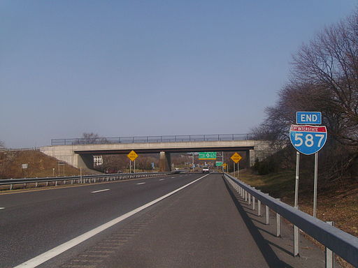


 I-587, known as Colonel Chandler Drive, is co-signed with NY 28. It is a full freeway from it’s start at a traffic circle near the New York State Thruway (I-87) to its eastern terminus at an intersection with NY 32 (Albany Avenue) in downtown Kingston. Other than its termini, it has no exits. It also never meets its parent route, I-87, though the traffic circle at the western end does connect to Exit 19 of the Thruway.


 Despite being one of the coolest extant Interstate numbers, I-444 is unsigned. Instead, it carries US 75 designation for its entire length, as well as US 64 and OK 51 for part of its length. It’s curious that they chose not to sign it. According to

 Today for no particular reason we visit NY 135, the Seaford–Oyster Bay Expressway. It runs north-south through suburban Nassau County on Long Island. What makes it interesting is that it seems rather incomplete. NY 135 was intended to continue south to Jones Beach, but this part of the project was never completed. One can see the right of way extending south from Merrick Road (once the main east-west thoroughfare on the south side of Long Island) to the Wantaugh Parkway.

")


 Officially the “Long Beach Freeway”, the highway runs alongside the Los Angeles River for much of its length. The Los Angeles River is a naturally flowing river, but it has been encased in a concrete channel. It’s a rather dystopian vision, but very much characteristic of 20th century LA. It has served as a setting for numerous movies – think the scene in Terminator 2 where the cars crash in a giant concrete ditch and the shapeshifting guy walks away. Of course, I had to photograph this monument myself as well. I joined I-710 at its interchange with Highway 91. The river immediately comes into view to the right, concrete channel and all. However, along this section there has been a lot of work to provide green space on the banks, with bike and walking paths connecting a series of parks. I left the freeway at the Imperial Highway exit for a closer look.


 Today, we visit the Ed Koch Queensboro Bridge to mark the passing today of former New York Mayor Ed Koch. The bridge, which carries New York State Route 25 from Queens to its terminus in Manhattan at 2nd Avenue, is known locally at the “59th Street Bridge.” It’s actually over 100 years old, having opened in 1909.
.jpg)