Alabama remains a somewhat mysterious place to us at CatSynth – it’s one of only six states I haven’t yet visited. We did take fellow readers on a virtual drive of the state during our 2012 Primary Highways series. Today our virtual trip heads north from Birmingham on I-59 towards the town of Gadsden, Alabama.


 Gadsden is the largest town in and the county seat of Etowah County and has a population of about 35,000. To put this in perspective, it’s a little over half the size of Santa Cruz, California, where CatSynth began. But unlike Santa Cruz, Gadsden boasts its own Interstate highway, I-759. It begins at an interchange with I-59 west of town and then crosses a long causeway of a wide section of the Coosa River before ending a junction with US 441 and Alabama State Route 759.

 US 441 (Rainbow Drive) continues northward along the Coosa River, passing by the revitalized downtown area bere a junction with US 431 and US 278. It now includes galleries, boutiques, institutions like the Gadsden Museum of Art and the Mary G. Hardin Center for Cultural Arts, and a park along the Coosa River. The museum has a current exhibition Intersection from Highway 90 that looks quite interesting.

[Mary G. Hardin Center for Cultural Arts]

[Spirit of American Citizenship Monument along Coosa River. By Prestinian at en.wikipedia (Transferred from en.wikipedia by Ronhjones) [Public domain], via Wikimedia Commons]
Heading back south on US 441 to the interchange with I-759, we come to an altogether more pedestrian institution, the Gadsden Mall. The mall itself seems like a bit of a throwback to the 1970s and 1980s, with textured concrete siding that doesn’t quite rise to the level of brutalism; and with Sears (Sears?!) as an anchor along with Belk, a southern department-store chain. The mall is now somewhat infamous as the haunt of a certain Etowah County assistant district attorney named Roy Moore, who was known by locals to cruise the mall for teenage women, leading to what was at least an informal ban from the mall (or as one victim put it “he was run off”).
Reading the stories of the women in this New Yorker article and AL.com are chilling, and our thoughts are with the victims who told have come forward to tell their stories. This guy is at the very least a serious creep, and worst a serial pedophile and sexual predator. But the other thing that baffled me in both articles was how this was an open secret of sorts in Gadsden. People know about and clearly disapproved of his behavior. So how did he rise from local creep and pedophile to the Chief Justice of the Supreme Court of Alabama twice? Why didn’t the people of Gadsden warn the rest of the state about him?
Looking back at Moore’s electoral history, he did face scrutiny and lost multiple elections, including for County Judge and later for Etowah County District Attorney. It was only several years later that he was appointed to the circuit-court seat he had earlier lost. Again, one wonders how he passed the background checks. But with the power of incumbency and his fiery extreme-Christian rhetoric, he was able to the gain election to the seat and eventually to the State Supreme Court, where he was removed twice for defying court orders in the name of his extreme brand of religion.
It is the last point, his extreme theocratic views on religion as law and his bigotry towards just about anyone who doesn’t share his beliefs, especially to the LGBTQ community and even towards Jews, that made him abhorrent long before the charges of sexual abuse and predation arose. The charges should alarm those who claim to share his “Christian” beliefs, but if anything it seems to have had the opposite effect, with some doubling down in their support in that siege mentality that seems to be universal among the religious right as well as many white nationalists and supremacists. Like Trump, he has become a symbol for the inchoate rage in many communities across the country.
I know the last thing the people of Alabama want is some liberal Jewish New Yorker telling them what to do or how to vote. I do hope they do make the right choice and reject this man who is so awful in so many ways from representing their state. Regardless of the outcome, I am sincere in my desire to hopefully visit Alabama soon, explore and play some music shows. Any leads or suggestions in this regard are welcome!
See more of Gadsden Alabama and many other fine towns across North America in our Highway☆ app, available on the Apple App Store and Google Play Store.
 .
. 

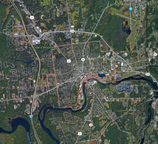


 As we can see from this map, it is just east of Interstate 87, here the Adirondack Northway, so the name for the beer is not at all surprising. US 9 also goes through the town center, as does one of its myriad auxiliary routes, NY 9L, and NY 32 which like US 9 and I-87, follows the Hudson River.
 The geography of San Francisco is complicated, and the east and west sections of the city can sometimes seem quite divided. This is even more so when one is transporting a cat across the city, as I did on Thursday to bring Sam Sam from CatSynth HQ in the downtown area to our longtime vets at

 The Sunset is an interesting and intriguing place, almost a separate city. From 19th Avenue (CA 1), the alphabetically arranged streets and numerically arranged avenues slope gently down towards the Great Highway and the ocean. The Great Highway should be CA 35 all the way up to its northern end, rather than ending in the southern corner of the city along Sloat, but it does. Especially Cats is on Taraval Street, one of the main east-west strips in the neighborhood. It even boasts a streetcar line down to the sea.
 This photo was from 2015 when I brought Luna in for her biopsy. It was a normal overcast gray summer day in the Sunset. Sam Sam’s visit was on a hazy sunny and warm day at the start of the current heatwave. The return to Especially Cats was a warm experience as well, albeit a bit emotional as it was our first reunion since Luna passed away. Fortunately, Sam Sam received a clean bill of health and charmed the staff with her cuteness. And she was remarkably well behaved on the trip over, just complaining a little bit. We decided to take the more geometrically direct but hilly and windy route back, taking Taraval to its eastern end a swanky neighborhood around Laguna Honda, and then over Portola and Market back to our corner of the city. The spot where Market and Portola meet is among my favorite in the city, with commanding views of downtown and beyond. And in between, there are dips and valley with unexplored roads and walks that I need to come back to when I don’t have an impatient cat in a carrier.


 The downtown is wedged between the two upper rivers and enveloped by a network of highways including I-279, I-376, I-579 and PA 28. In this early-morning photo, we are looking across the Monongahela River, with I-376 along the shore and the skyscrapers of downtown behind it. As a city of rivers, it also becomes a city of bridges.


 We would be remiss if we did not also give a shout-out to our friends at Pittsburgh Modular Synthesizers. We have several of their modules, which feature a classic mid-century design aesthetic. (They also include space-themed cards and tchotchkes in each box.) You can read our


 Highway 162 crosses the bridge, and connects the town of Oroville to Highway 70 and the Sacramento Valley. Highway 162 continues westward towards the wide flat Thermalito Afterbay, a wide shallow reservoir that is part of the Oroville system, and serves both agricultural water delivery and regulation of the main lake and the power plant.
 Highway 70 heads southwards towards Sacramento, passing the towns of Marysville and Yuba City , where it continues as a freeway towards Sacramento. Yuba City is interesting as the home to perhaps the largest Sikh community outside the state of Punjab in India. Many of the Sikh settlers in the area became farmers, in particular peach farmers. And the town hosts a large annual festival that brings in thousands from outside the area.

 We begin our exploration in a quiet and somewhat industrial section of Long Beach along Willow Road. Seemingly in the middle of nowhere, we encounter the northern California Highway 103, the Terminal Island Freeway which is a major truck route to the port. It might be the heavy truck traffic that accounts for its being in rather poor shape.
 Heading south on CA 103, we pass through a flat, industrial landscape. It is a bit desolate, but beautiful in its way. There are only two interchanges, one of which is with CA 1. Continuing past the interchanges, the freeway transitions to California Highway 47 and crosses the Cerritos Channel to Terminal Island the ports on the Commodore Schuyler F. Heim Bridge. This is a massive lift bridge that can accommodate large ships accessing the port.


 Between the station and the park is the Sheridan Expressway (I-895). This is a strange little highway that hugs the western edge of the Bronx River from the Bruckner Expressway (I-278) north to East Tremont Avenue with connections to the Cross Bronx Expressway (I-95) and the Bronx River Parkway.


.jpg)