In this installment of our “primary highways” series, we look at the states of Mississippi and Alabama. In some ways, this is a particularly challenging edition, as I have never personally visited either of the states – in fact they are among only five remaining states I have yet to visit (Kansas, which held its causes on Saturday, is another of the five). So we will do the best we can.
 I did come close to visiting Mississippi in 2006. For one day while I was in New Orleans, I had rented a car to reach places outside the public transportation grid that was still limited after Hurricane Katrina, including the Lower Ninth Ward. I was tempted to get back on I-10 and head east to Mississippi, just to be able to say I was there. But in the end I decided against it. Had I continued, I would have crossed into Mississippi in a sparsely populated area along the Pearl River. To the north of I-10 is the John C Stennis Space Center, where NASA has tested engines for many of our legendary space vehicles including the Apollo Saturn V and the Space Shuttle.

G iven that it is an engine test facility, it’s not surprising there isn’t much of a permanent population in the area. Several communities were removed when it was built, and supposedly a few remnants of the communities, particularly Gaineville, still exist. Indeed, off of Highway 607, the “Shuttle Parkway”, is Lower Gainesville Road, which heads past various space-center complexes towards the Pearl River and ends at what could be the remains of the town.
 Heading southward on 607 from I-10, we eventually reach US 90, which continues along the Mississippi coast through the towns of Waveland and Bay St Louis, which were devastated by Hurricane Katrina. Perhaps the most dramatic example was the bridge carrying US 90 over St. Louis Bay, which was completely destroyed.

It has since been replaced by a new bridge, a graceful flowing structure that has won the American Transportation Award and became a symbol for the region.

[By Frank Kovalchek from Anchorage, Alaska, USA [CC-BY-2.0], via Wikimedia Commons]
US 90 continues along the coast as Beach Boulevard towards the cities of Gulfport and Biloxi. Biloxi is a big resort and casino town on the coast, but it, too, was devastated by Hurricane Katrina. Although it sounds like there is still much rebuilding to be done, many of the city’s casinos have since reopened and landmarks restored including the iconic Biloxi Lighthouse and the Ohr-O’Keefe Museum Of Art that was designed by Frank Gehry. The Ohr-O’Keefe was under construction when Katrina hit and was severely damaged. It ultimately opened in 2010.

[By Woodlot (Own work) [CC-BY-SA-3.0 or GFDL], via Wikimedia Commons[]
South of nearby Gulfport is Cat Island. I thought maybe it had something in common with the famous Cat Island off the coast of Japan, but no such luck. As far as I can tell, there are no cats there, and the name itself was a mistake.

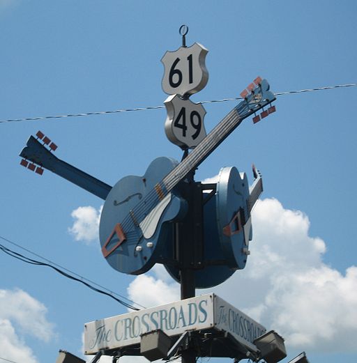
 From the southeast corner of the state, we jump to the northwest corner. Specifically, we are going to a junction outside of Clarksdale where US 61 and US 49 meet. This crossroads is considered by many “the crossroads”, where according to legend blues musician Robert Johnson sold his soul to the Devil in exchange for his musical gifts.

[By Joe Mazzola [CC-BY-SA-2.0], via Wikimedia Commons[]
Legend or not, Clarksdale has a particular association with the blues, and is home to the Delta Blues Museum.
US 49 has long been a major highway traversing the state diagonally. From Clarksdale, it winds its way through the Mississippi Delta, even splitting into separate east and west parts, before leaving the delta and approaching the capital and largest city, Jackson. On the northwest approach to the capital, US 49 carries the name Medgar Evers Boulevard in honor of the civil rights leader who was assassinated in Jackson in 1963. The highway then bypasses the downtown with I-220 and I-20 before continuing to Hattiesburg, home of Southern Mississippi University.
 In Hattiesburg we meet I-59. The drive along I-59 and US 11 to the town of Laurel was recommended to me (actually, the drive south from Laurel to Mississippi State University). In Laurel, I-59 had an unusual S-curve that rivaled Dead Man’s curve in Cleveland due to railroad overpasses, but it has supposedly been reconstructed. I-59 continues north to Meridian, where it joins with I-20.
 Briefly leaving the freeway in Meridian, one can take Highway 19 north to the town of Philadelphia, made infamous for the death of three civil rights workers James Chaney, Andrew Goodman and Michael Schwerner. The murders took place off of Highway 19, and it was presumably the route they took to Neshoba County.

 I-59 and I-20 continue as a single route into Alabama, all the way to Birmingham. It is largest city in either of the states in this article, and is crisscrossed by several major highways. A large interchange between I-59/I-20 and I-65 just west of downtown is known as Malfunction Junction because of the frequent (and unfortunately, sometimes deadly) accidents that happen there.

[Click to enlarge.]
Interestingly, it does not look that complex from a map view, especially when compared to a nearby junction of I-59/I-20 and US 31/US 280. While it does look more complex, it does afford a good view of the city skyline when approaching from the south.
Birmingham has a strong industrial past, especially in iron and steel. Indeed, the Sloss Furnace in the city is one of the few industrial sites preserved as a National Historic Landmark.

[Timjarrett at the English language Wikipedia [GFDL], from Wikimedia Commons]
Visitors can wander and enjoy the site, which features defunct but preserved industrial buildings and machinery. This would be a fantastic place to photograph! I could also see it as a musically inspiring location, for pieces based on metallic resonances. The center does hold concerts, and has a highly regarded program in metal arts. (I wonder if they have arts residencies?)
As has happened with many other industrial cities that experienced long declines, downtown Birmingham appears to rebounding as a residential and cultural center, with lofts and galleries. There is also the restored Alabama Theatre which functions as a performing arts center while retaining many of its movie-palace features, most notably its original Wurlitzer Organ. (It should be noted this is the second Wurlitzer to be featured in this year’s “primary highways” series.)

 South of Birmingham is the town of Selma, which has a storied place in the Civil Rights Movement. A voting rights movement in the town ultimately grew into the Selma to Montgomery Marches in 1965. The marches took place on US Highway 80 heading east from Selma and crossing the Edmund Pettus Bridge.

The first march was met by state troopers and the marchers were brutally assaulted. Images “Bloody Sunday” were broadcast nationwide, shocking many and galvanizing support among some for the civil rights movement. Two more marches along the same route were organized. The third march passed the bridge and continued all the way east on Highway 80 to Montgomery. The march then veered north onto the Mobile Highway, parallel to present day I-65, and then along city streets to the state capitol. The entire route is now marked as the Selma to Montgomery National Historic Route.

 From the state capital, one can travel south on I-65 to Mobile and back to the Gulf Coast, where we began. We switch on to I-165 which enters the downtown and becomes Water Street. Heading further south, we come back to I-10, which crosses Mobile Bay on a long causeway. From the causeway, we can look back at the city at sunset.

[Photo by faungg on flickr. (CC BY-ND 2.0)]


 Despite being one of the coolest extant Interstate numbers, I-444 is unsigned. Instead, it carries US 75 designation for its entire length, as well as US 64 and OK 51 for part of its length. It’s curious that they chose not to sign it. According to kurumi.com, “a mapping supervisor from Oklahoma DOT spoke to the Division Engineer in Tulsa to get a more official answer. To avoid confusing motorists by adding a 444 number to an area with I-44 and I-244, the DOT decided to use the existing US 75 designation.” Honestly, that seems like a weak reason. We have I-80 plus seven different x80 interstates here in the Bay Area and manage not to get too confused by it.

 Today for no particular reason we visit NY 135, the Seaford–Oyster Bay Expressway. It runs north-south through suburban Nassau County on Long Island. What makes it interesting is that it seems rather incomplete. NY 135 was intended to continue south to Jones Beach, but this part of the project was never completed. One can see the right of way extending south from Merrick Road (once the main east-west thoroughfare on the south side of Long Island) to the Wantaugh Parkway.

")


 Officially the “Long Beach Freeway”, the highway runs alongside the Los Angeles River for much of its length. The Los Angeles River is a naturally flowing river, but it has been encased in a concrete channel. It’s a rather dystopian vision, but very much characteristic of 20th century LA. It has served as a setting for numerous movies – think the scene in Terminator 2 where the cars crash in a giant concrete ditch and the shapeshifting guy walks away. Of course, I had to photograph this monument myself as well. I joined I-710 at its interchange with Highway 91. The river immediately comes into view to the right, concrete channel and all. However, along this section there has been a lot of work to provide green space on the banks, with bike and walking paths connecting a series of parks. I left the freeway at the Imperial Highway exit for a closer look.


 After a few cold weeks in the city, I am looking back fondly at my trip to the desert this past summer. Today we look at the final leg of that trip, leaving Joshua Tree on Highway 247. I had been curious about this highway which heads north from Yucca Valley at a junction with Highway 62 out into the desert hills. There is actually quite a bit of residential development near the start of highway, with a great many dusty side streets with a diverse collection of homes. I acquired one of my sculptures at the home of an artist there several years ago. But on this occasion, I kept going north. One of first reassurance markers was, appropriately enough, next to a joshua tree.


 Here, 247 turns north towards Barstow, so I switched onto Highway 18 heading east out of town. This odd highway winds around the mountains and valleys of San Bernardino county through a variety of geographies. The section that I traveled started with crumbly red-brown rock formations up against the sparse commercial development of the town. After an empty section, the road entered the town of Apple Valley where the landscape turned all of a sudden into suburban development and the highway became a multilane expressway known as the “Happy Trails Highway”. The sharp contrast was a little jarring, but not unexpected given the history of development in the deserts north and east of Los Angeles. But this was not the stark industrial development as I had seen in
 Sometimes I just need a virtual escape based purely on numerical criteria. Such is the case with I-990, the highest-numbered Interstate highway in the U.S. It is a relatively short spur highway northeast of Buffalo, New York, and carries the name Lockport Expressway, suggesting that it was intended to connect from I-290 north of Buffalo to the town of Lockport. We did visit Lockport in our


 From there, we turned north onto the service road for the Henry Hudson Parkway (NY 9A), which we followed for a distance. Though this mostly provided a view of the parkway itself, one could also look past it towards the Hudson River. Ultimately, we turned away from the parkway onto West 235th Street, crossing Johnson Avenue again in the “downtown” section of Riverdale. The exact route we took to get there is a bit fuzzy, but I attempt my best guess in the map above.
 I-380 is a short connector between I-280 and US-101 just north of San Francisco International Airport. The bus ride on I-380 to I-280 and the Daly City BART station was one of my first experiences in California (at that time BART did not yet extend to the airport). In the years since then, I have been through this interchange too many times to count. Here is what it looks like from above:


.jpg)