Well, after several weeks off, we resume our “primary highways” series with a trip to Pennsylvania. And once again, we find ourselves on I-80.
We begin with this interesting photograph from the completion of I-80 at the Milesburg Interchange, from the site pahighways.com. The east and west destinations are reminders why we keep coming back to this particular highway throughout the series.


 I-80 traverses a path through the center of the state, though hills and valleys, mostly avoiding larger towns and cities. It is also famously windy and difficult to drive, particularly the eastern half. Indeed it has been cited as one of the “worst roads” multiple times by truck drivers and others. Nonetheless, it is quite scenic, and it does pass by a few notable places. Just south of that cool sign in Milesburg is State College, not surprisingly the home of Penn State University. This school is huge. There is Punxsutawney, the town made famous by the classic film Groundhog Day. Yes, they do have a groundhog there. On the eastern edge of the state, I-80 passes through the mountainous region around the Delaware Water Gap, a frequent “first stop” on trips heading west from New York.
In the northeast, I-80 also passes through the area that includes industrial towns such as Scranton and Allentown, which have been much talked about in the recent campaign. Hillary has some heritage here (and support). It is also where the media is looking for “drama” after Barack Obama's recent comments – I do sympathize with him, but I am holding back from jumping into that milieu. Let's get back to the road…

 …much of the action is actually to the south, on Pennsylvania's other major east-west highway: I-76, the Pennsylvania Turnpike. It connects the major cities of Pittsburgh and Philadelphia, the capital, Harrisburg, and New Jersey. I have never been to Harrisburg or Pittsburgh – though I can name all three rivers, which I leave as an exercise to the reader.
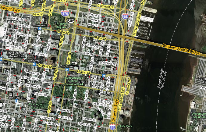
According to the site Philadelphia Highways (part of pahighways.com), “Interstate 76 happens to come through the city just a few miles from where the Declaration of Independence was signed in 1776.” Seems like too much of a coincidence, but it is actually the most appropriate number on the interstate grid. And for actual proximity, I-676 and I-95 are even closer to Independence Hall:

[Click to enlarge]


Philadelphia has an interesting dual identity. One is its central role in the history and “mythology” of the United States. (One of the “myths” is that is was the first capital. That was actually New York!) The other is simply being the sixth largest city in the U.S., with life and culture of its own outside the historical sites. It also has a reputation as one of the more dangerous cities. Nonetheless, I have visited several times with no negative experiences. I do feel bad for cities that have a lot to offer, but get tagged with that label. New York certainly went through that as well. We will see how things go for the “City of Brotherly Love” – I would certainly welcome comments from anyone who has lived there…
 And we can't close this article without mentioning I-99. I-99 is infamous among some highway enthusiasts for being numbered so inconsistently with the rest of the grid, and for being a construct of pure political vanity. Again, from pahighways.com:
In 1996, Representative Bud Shuster who acquired funds for the upgrading of US 220, had this highway designated an Interstate in Section 322 of the National Highway System Designation Act of 1995…Bud had his highway designated I-99 and had the designation written into law. It was bad enough it runs past his son's car dealership, and violate Interstate highway numbering system too! It should have been numbered I-576, 776, or 976. I like the last…a fitting number for someone that had been under investigation for illegal highway funding acts.
The currently completed section if I-99 takes us back to State College, where we began.
 The Bay Bridge has been closed over the Labor Day weekend for a major engineering feat. As part of the replacement of the eastern span, engineers actually cut out a small section near Yerba Buena Island, and actually wheeled in a new section of bridge. This allows the old doomed bridge to be used while the new one is connected up to the island.


.jpg)


 The featured photography exhibit of
 The next exhibition takes us from the amazingly timely to something “out of time.” Indeed, the title of