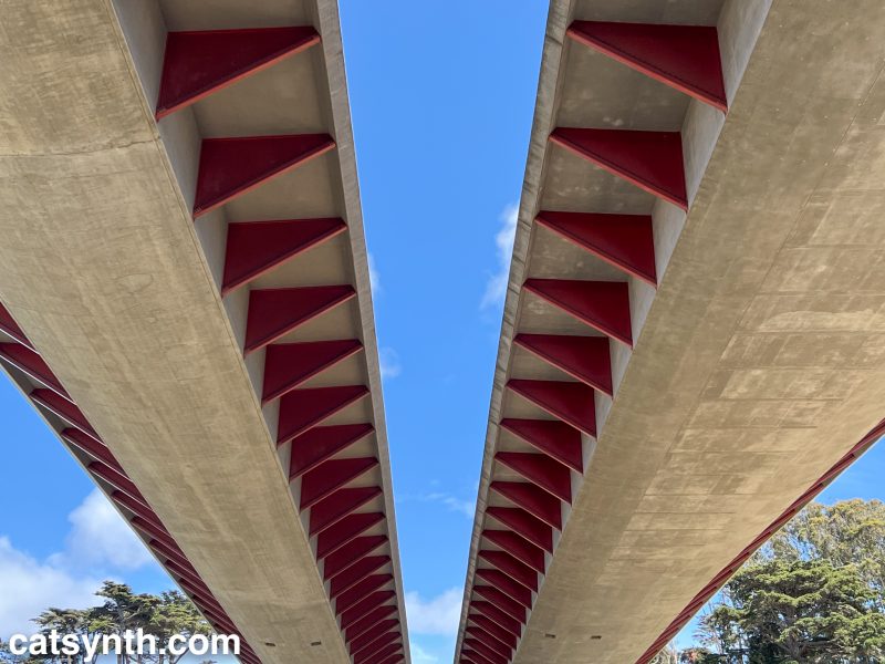
Underneath the Presidio Parkway (US 101) as it approaches the Golden Gate Bridge. It passes over a hillside that includes the Presidio Pet Cemetery. If you haven’t yet seen our video about this special place, please check it out below.

There was a brief period of respite at the beginning of August between the end of the Outsound New Music Summit and the start of a new job. Time was tight, so there wasn’t time for an extended odyssey in the deserts of southeastern California. But the north coast, specifically Humbolt County and the area around Eureka, were well within range for a two-day trip. I have never been that far north on the coast. I got an Airbnb in Eureka. I researched a mixture of industrial and natural spaces for photography and exploration. I even got a new lens for the big camera. And early on Saturday morning (or at least early by CatSynth standards), I was ready to go.
 Eureka is a direct shot up US 101 from San Francisco, about a four-hour trip in good conditions. It’s a major freeway up to the border between Sonoma and Mendocino counties, and then a mixture of an expressway and a two-lane road through the redwoods, with spots of freeway near major towns.
I never made it to Eureka.

 The beginning of the trip was enjoyable and largely uneventful – and the Russian River gorge section after crossing into Mendocino County is spectacular. North of Ukiah, I felt like I was actually transitioning into exploration, as this was somewhat novel territory (technically, I had been as far north as Legget in 2013, but that was in the evening and rushed). Once CA 20 joins with 101 north of Ukiah, the combined route begins a long, steep grade into the hills. It is here where things started to go a bit wrong. The temperature gauge on the car, usually quite steady, suddenly shot up beyond the red “H”. This is definitely not good. I shut off the air conditioning and things calmed down a bit as we got into the new Willits bypass, a Super-2 limited access highway. North of the bypass, 101 becomes a steep windy road through the woods; the temperature gauge shot up again. This was definitely not good. I limped back to Willits to give the car a break and figure out next steps.
I’ve been through Willits a few times, but never really stopped there. The little downtown has some cute old brick buildings. But I had no time to play – I needed to find a repair shop. Nothing showed up in Yelp as open. I probably should have called AAA at this time, but I did find an open shop in Ukiah, so I limped back. I drove conservatively, with the windows open, the vent fully open, and one eye on the temperature gauge.
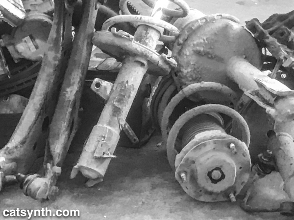
I was relieved when I finally pulled into Tony Lopez Automotive. It was out a strange little industrial side-street south of downtown. Tony was clearly not pleased to have someone wander in with car trouble just as he was getting ready to close, but he was also chivalrous and ready to help out a damsel in distress. We got the car cooled down; and after a bit of diagnosis, he identified a small but pernicious radiator leak. The diagnosis took some time, and while I was sitting I noticed a rather interesting pile of old car parts. I snapped an iPhone photo, which became a Wordless Wednesday featured a couple of weeks ago.

I regret not grabbing my better camera out of the car to get a higher-quality image, but it was not my priority at the time. And I do like the abstract quality the pixelation provides. Tony did notice the fancier equipment still in the car, though, and it sparked a conversation about my writing and photography and about this site. I wonder if he has checked it out.
Once things were ready, I left town – I would have loved to stay, but I was eager and anxious to get home. I also left Tony Lopez a glowing Yelp review. If you on 101 in the vicinity of Ukiah and need auto help, please patronize his shop and tell him that Amanda from San Francisco sent you.
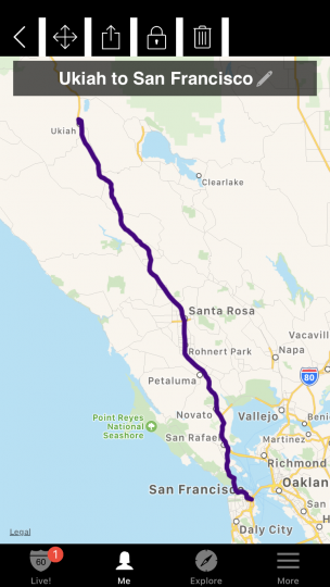
The trip back to San Francisco was sad but uneventful, and in this case uneventful was good. I didn’t record the trip back on Highway☆, but here is the exact same trek that I did record on a short but happier trip in July.

The engine temperature stayed within an acceptable range, and it was fine over the next few days in San Francisco, but the radiator definitely needed to repaired ASAP. This experience also cured me of any sort of “fun with highways” wanderlust for a while and I have remained close to home since then (except for μHausen). But the bug is starting to come back, and I might have to start exploring again. I might even make it to Eureka one of these days…
See more of Northern California and many other fascinating places in our Highway☆ app, available on the Apple App Store and Google Play Store.


We at CatSynth love traveling and exploring our adopted home state. This includes day trips from the Bay Area as well as longer adventures. But one thing remains a bit of a challenge. For much of the state, the main highways are primarily north-south, with very few east-west routes. One chooses one of the long-haul north-south highways, California 1, US 101, I-5, California 99, or US 395 and is pretty much locked in with only a few options for efficiently traveling east to west. There is I-80 in the middle north, California 152 or California 46 from the coast through the Central Valley and California 58/I-40/I-15 further south.
North of Sacramento, east-west travel becomes even more difficult, with routes like California 20 and California 299 being relatively rural and windy for much of their length. The end result is that most of our trips – especially single-day trips heading north – are forward and back along one of the main north-south routes unless we have extra time or necessity to use the smaller east-west roads.


This north-south bias can be seen in an almost self-similar way when zooming in on the extended Bay Area. South of San Francisco, there is California 1, I-280, US 101, I-880, I-680 and then not much at all until one gets to I-5 in the Central Valley.
.png)

In the North Bay and wine country, a similar pattern appears with CA 1, US 101 and CA 29, with another large gap until I-505 and I-5. We have made use of east-west roads like CA 128 to get between them as in our recent wine-country trip that featured Elsie the Library Cat. But this is a long detour.
This north-south axis may be frustrating at times (especially the further north one gets), but there is nothing particularly sinister about it. It’s all a matter of Calfornia’s geology. The interface of the Pacific and North American plates that give us our reputation for earthquakes also lead to long bands of north-south mountain ranges and valleys. The Sierra Nevada may be the most dramatic, but it is only one of several that form vertical stripes, with the Central, Sacramento, Salinas, and Napa valleys in between. The San Francisco Bay can be seen as another such valley in a way, with shallows bounded by high hills running north-south.
The exception to the “north-south rule” can be found south of the San Gabrial mountains and into the desert. From Los Angeles and San Diego, one can easily travel east-west to the desert towns and to the Arizona border on I-10 and I-8, with a network of other east-west freeways in between. It is definitely a different experience traveling down there once one gets over the Grapevine or the Tehachapi Pass and into the southern realms. As for the rest of the state, there is no escaping the geographic reality, so it is best to embrace it, and even enjoy it.
17th Street is one of the longer numbered streets in San Francisco, though not the longest. What makes it unique among its peers is that it forms an almost perfect horizontal line through a large swath of the city, cutting through a variety of neighborhoods and terrains. Like reading geological strata or tree rings, it is an efficient way to explore San Francisco’s geography and history. For quite a long time I have wanted to walk the length of 17th Street. And on March 17 of this year, things lined up in terms of numbers, schedule and weather to make the perfect day for this walk.

17th Street begins at a modest corner with Pennsylvania Avenue at the base of Potrero Hill, next the I-280 elevated section. This used to be a rather forlorn block, but it has been upgraded quite a bit with the addition of a small park at the end of the street.
The street then heads westward through the flat land below Potrero Hill and crosses many of the streets named for U.S. states. Along the way one passes Bottom of the Hill, a club that I recently played at (you can read the gig report here). There is also Parkside, where I have yet to play. The architecture in this area changes between industrial and the modest wooden houses that typify San Francisco. There is also some newer condo and office development.

The street then heads uphill and underneath the US 101 freeway. From here, one can look down at the junction with I-80 and the downtown skyline beyond.

This neighborhood, at the boundary between Potrero Hill and the Mission is the location of Art Explosion, where I have had photography shows over the past couple of years. I have since left that space in order to focus on my other creative projects. From here, 17th Street heads downward into the Mission.

This is a huge neighborhood with numerous subsections each with their own character. We start off in a very industrial area that continues until we cross South Van Ness, at which point we enter the very densely packed core along Mission Street. Continuing westward we find ourselves in the heart of San Francisco hipsterdom, particularly along Valencia Street and the wide park-like Dolores Street.

The houses along this section of the street are a more upscale variety of the ornate San Francisco Victorians, some in colors that one would never instinctively think to paint a house. There are also numerous alleys that poke in either direction off the street.


From here, we continue eastward into the Castro. I have never been entirely sure where the Mission ends and the Castro begins, but I think it is probably at Church Street. Further on it becomes pretty clear where we are as 17th Street approaches its six-point intersection with Market and Castro streets. At this intersection, we find the huge landmark pride flag.

This is also the terminus for the F-Market streetcar line, which uses vintage streetcars from around the world.

After crossing Market Street, we come to the 4000 block of 17th. We have already come a long way, but there is still quite a bit ahead of us.

From here, the street heads up a steep hill into a very upscale neighborhood with large (and undoubtedly very expensive) houses. While 17th Street remains straight as it goes uphill, the intersecting streets, a few of which are named for planets, are more curved and follow the contours of the terrain. There are also numerous staircases here, providing access where it is too steep to build cross streets or alleys.

17th Street eventually reaches its apex at a large intersection with Clayton Street. To the south is Twin Peaks. To the north is Mount Olympus, the geographical center of the city. I had explored the strange little park at that point on a previous excursion. There is a pedestal that presumably contained a statue at one point. I used it as a backdrop for some of my doll photos, one of which you can see here. From this point, 17th drops precipitously into the Cole Valley neighborhood.

This section is purely residential, and the streets straighten out. Even after descending the hill, the street still remains higher than the rest of Cole Valley and the Upper Haight to the north. 17th Street comes to an end here at an intersection with Stanyan Street.

Thus, the mission to walk the length of 17th Street was complete. But this was not the end of the story. The city recently opened the long-closed Interior Greenbelt park, and the main trail begins half a block away on Stanyan. One ascends a narrow wooden staircase and enters into a completely different world.
 1
1
I am surprised I had never before made it to this gem of a park, though it did only open to the public in 2011. The woods are not unlike those one might find in parks outside the city, with no visual cues of the urban surroundings at all. There are some sounds from the city that penetrate into the woods, but they are overshadowed by the combination of silences and natural sounds. The late afternoon lighting was perfect on this trip as well. I spent about 30 minutes or so wandering the main “historic” trail of the park before exiting on a small brick-paved street with a spectacular view of the city.

Tired but contented, I picked up a nearby MUNI Metro to get home. And this really is the end of the journey.